Subdivision is a popular method of releasing the financial equity in your property. This article will break down the steps for you, explain the basics of subdivision as well as what you need to be aware of and the key features of the typical subdivision layouts.
Subdivision Process
Subdivision involves designing a development layout for your property that meets your local council’s town planning policy framework, and also complies with the regulations governing Victorian subdivision, commonly known as ResCode. The local regulations vary from Council to council meaning that a subdivision proposal in the Monash or Boroondara Council area may not receive support in neighbouring Whitehorse Council or nearby Banyule Council or Glen Eira Council. It is important to engage a professional with local experience before commencing to avoid common pitfalls.
There is no one Council that is more ‘difficult’ to work with than another to get a subdivision approved but it is true to say that the processes vary between each so you should engage a professional firm with local experience and relationships. You can read some of our success stories by cicking here or visting our subdivision section. Once we have obtained subdivision consent from your local council we must then connect the newly created block(s) to the sewer, electric and water infrastructure.
Typical Subdivision Lot Layouts
Depending on the lot arrange of the property, there are three common layouts for two dwelling subdivisions.
Existing Dwelling with One New Dwelling
Typical Lot Arrangement with one existing dwelling at the front of the property with space to subdivide and develop at the back of the property. Both dwellings will be serviced by one single existing accessway.

Key Point 1:
Rear private open spaces are required for both existing and new dwelling. It is important to confirm the required size with the local council and local planning scheme.
Key Point 2:
Proposed subdivision line will be drawn on the edge of both dwellings and a common drive way will be created.
Key Point 3:
New double garages for each dwelling. State Planning Scheme typically require minimum of 2 car spaces per 3 bedroom dwelling.
Key Point 4:
Common driveway will require minimum of 75 square metres to allow for vehicle turning circles.
Key Point 5:
Driveway is required by the planning scheme to be 3 metres wide at minimum.
Key Point 6:
It is recommended to have 500mm – 1 metre landscape buffers on either side of the driveway. This will help maintain the neighbourhood characteristic and is widely accepted by local councils
Key Point 7:
Street trees, lights, local authority services may impact the proposed crossover location. Confirm relocation of service may be required at developer’s expense during permit application process.
Two New Dwellings Side by Side
Some designs consist of two new dwellings side by side with both dwellings having their own street frontage and direct access to the road from garage. New accessways will be required and each dwelling will have its own private driveway.

Key Point 1:
Rear private open space are required for both dwellings to comply with ResCode requirements. It is important to confirm the required size with the local council and local planning scheme.
Key Point 2:
Proposed subdivision line will be drawn in the middle of the dwellings, usually a single solid wall.
Key Point 3:
New Single garage plus one tandem car space for each dwelling. State Planning Scheme typically require minimum of 2 car spaces per 3 bedroom dwelling.
Key Point 4:
The design will propose slight variation to front and rear setback to both dwellings. The aim is to create its own identity for each dwelling and avoid mirrored designs.
Key Point 5:
Driveways are required by the planning scheme to be 3 metres wide at minimum.
Key Point 6:
It is recommended to have 500mm – 1 metre landscape buffers on either side of the driveway. This will help maintain the neighbourhood character.
Key Point 7:
Street trees, lights, local authority services may impact the proposed crossover location. Confirm relocation of service may be required at developer’s expense during permit application process.
Key Point 8:
First floor takes shape of “wedding cake” design to comply with local planning scheme and ResCode requirements.
Corner Lot with One New Dwelling on the Side
A major advantage of a corner block is that each dwelling will have greater sense of privacy and identity. Each dwelling will have its owndriveway access points and both dwellings remain separated from each other. Corner sites are often refered to as the easiest type of subdivisions for this reason.

Key Point 1:
Rear and side private open spaces are required for both dwellings to comply with ResCode requirements. It is important to confirm the required size with the local council and local planning scheme.
Key Point 2:
Proposed subdivision line will be drawn in the middle of the original lot, usually in between the garages of the dwellings
Key Point 3:
New double garage for new dwelling. State Planning Scheme typically require minimum of 2 car spaces per 3 bedroom dwelling.
Key Point 4:
New single garage plus a tandem car space for existing dwelling. Requirement of minimum 2 car spaces per 3 bedroom dwelling remains applicable to existing dwelling.
Key Point 5:
Front setback to compliant with ResCode and confirm with local council if there are any overlay controls.
Key Point 6:
It is recommended to have 500mm – 1 metre landscape buffers on either side of the driveway. This will help maintain the neighbourhood character.
Key Point 7:
Street trees, lights, local authority services may impact the proposed crossover location. Confirm relocation of service may be required at developer’s expense during permit application process.
What happens after Council approve a planning permit for subdivision?
As the owner who benefits from the value of a newly created block of land it is important that you be aware that you must pay to connect the newly created block(s) to sewer, electricity and water infrastructure prior to the sale of the land. This connection process and the cost cannot be passed to a purchaser of a new block and the connection process must be completed before the new title for the block can be released. Our experts have completed this connection process on behalf of our clients in a number of metropolitan suburbs. We will ensure your connections and processed in an efficient manner which will save you time in completing the project.
Meeting Conditions on your Planning Permit
When all of the conditions of your council-issued planning approval are met, we can then obtain property titles for the newly created lot(s). Titles cannot be obtained until all conditions of your Council approval are met. The conditions on your Council approval will vary from Council to Council but our team know the conditions of Monash Council, Boroondara Council, Whitehorse Council, Banyule Council and Glen Eira Council intimately and can tell you exactly what is required to obtain the titles for sale. On obtaining titles this land can then be sold to a new owner or held by the current owner for investment purposes.
Get Assistance with Subdivision Planning Approval
There are various elements to be considered when subdividing land or buildings. These include:
- Real estate prices in your local area to determine whether the project will be profitable;
- Knowing the associated application costs of the Council and the infrastructure connection when completing a subdivision;
- An effective development layout so that the maximum value of the land is achieved;
- Being aware of any existing site features, such as trees and easements, which may restrict the subdivision potential of the land.
Remember, you can’t legally sell each of the new lots (even off the plan) in Victoria until the title for the new lot is released to your lawyer or conveyancer. To get the title released it is not enough to merely get your subdivision approved, you must then meet all of the conditions attached to that approval. If any one of the conditions attached to the approval of the subdivision is not met your title will not be released and legally there will be no sale allowed.
Ensure you understand each of the conditions attached to your approved subdivision and get on with meeting the conditions as soon as the approval is issued. This is extremely important if you have a buyer lined up subject to the title being released because the longer they have to wait for the title the greater the risk they will pull out of the arrangement.
One tip in closing is to make sure to complete the subdivision within the time limits. An approved subdivision does not run indefinitely on the site so make sure to complete the project within the time frame on the planning permit to avoid having to reapply and pay the fees again.
Our team has the vision, creativity and demonstrated industry experience to exceed your expectations and deliver a fantastic return on your investment. Take the stress out of your subdivision project by letting our experts complete the project efficiently and successfully.
The Andrews Government made a decision at a cabinet meeting on 17th Feb to sack the entire City of Casey Council amid controversial town planning decisions. Legislation is expected to pass by both houses of State Parliament. An interim administrator would be appointed to the council until 2024, the next eligible election for the council.
For months the Independent Broad-based Anti-corruption Commission has been examining council decisions related to property development and town planning in the City of Casey as part of Operation Sandon. It heard property developer John Woodman allegedly paid at least $1.2 million in bribes to former Casey mayors Sam Aziz and Geoff Ablett in a bid to win planning approvals for his clients.
Former mayor Sam Aziz, who is in Egypt on extended paid leave from his councillor position, allegedly received more than $900,000 from Mr Woodman. Councillor Geoff Ablett, a Hawthorn premiership player and brother of AFL legend Gary Ablett Snr, is accused of receiving more than $330,000. Former state Liberal MP Lorraine Wreford was hired by Mr Woodman as a lobbyist, and has been accused of delivering bags of cash to the councillors.
The investigation into Casey by IBAC has sparked internal reviews at Mornington Peninsula Shire, City of Kingston Council, Whittlesea council and Frankston Council to look into its own town planning decisions and approvals.
Mornington Peninsula Shire
Mornington Peninsula Shire mayor Sam Hearn said the council would conduct a review of planning applications and decisions. He noted the review could also examine decisions made by past state planning ministers.
“We want to show that we are here for the good of the whole community, not a small sector of property developers,” he said. “Even if that means going back and exposing historical situations and occurrences that weren’t up to standard.” The town planning approvals process is heavily politicised and the scandal engulfing Casey is causing a number of councils throughout the state to examine the town planning approvals process for large developments, rezoning and subdivisions.
Whittlesea Council
Whittlesea council will audit all applications and approvals of commercial and retail developments and residential developments comprising more than five dwellings that have been submitted to the council over the past five years. The probity audit will be carried out by the council’s audit and risk committee.
Whittlesea councillors have asked for the audit and risk committee to list any developments with which a number of individuals who have been named in the IBAC hearings were involved. Councillors have requested a list detailing the date of the development application and approval; what rezoning or planning permit application was involved in the development; and the names of lobbyists, town planners, property developers, landowners or other individuals who made representations to the council about the developments.
If needed, the council will seek advice about referring the committee’s findings to IBAC. Cr Lawrie Cox said the audit was necessary because the council was aware of a company named in the IBAC hearings being involved in developments in Whittlesea. “This is about making sure things are above board, and if not, giving them to IBAC to be cleared up. We need to get ahead of the problem rather than sit back and let it steamroll.” he said.
Kingston Council
Kingston council also commenced special audit of all development approvals from the past 15 years. The Kingston audit will also probe four specific projects in Kingston since 2004. Ms Wreford, who the IBAC hearings revealed had handed envelopes stuffed with cash to Casey councillor Sam Aziz, was from 2010 to 2014 the state MP for Mordialloc – a seat that is almost entirely within the City of Kingston.
Former Defence land in Mentone, which was once used as parkland and known as Chicquita Park but later redeveloped as housing, will be analysed in Kingston’s audit, as will the Waterways estate, a project on a low-lying floodplain that Mr Woodman was key to developing. The Kingston probe will also look into a Chelsea Heights rezoning mentioned in passing by witnesses at the IBAC hearings.
The anti-corruption commission is investigating allegations that Mr Woodman, a multimillionaire developer and planner, used Mr Staindl to gain direct access to state Labor MPs over his rezoning applications. Mr Staindl, who will give evidence to IBAC this year, also lists among his clients Alex Fraser Group – Recycling. Mr Staindl has been advising the company on its political strategy over a controversial glass and concrete crushing facility it has on land in Clarinda that is zoned green wedge.
A million tonnes of glass and building rubble are recycled at the site each year, and the company has been lobbying since Labor approved the recycling facility in 2008 to be allowed to stay indefinitely. Council officers have recommended against it.
Kingston councillor Rosemary West successfully pushed to audit projects involving Mr Woodman and others. She said the recycling company’s application should be viewed with scepticism. Given the revelations at IBAC about potential corruption involving lobbyists with close links to the Labor and Liberal parties in planning applications, particularly on land zoned “green wedge”, she said it was crucial Mr Staindl’s role in that application was made public.
“I hope this enables us to learn what other developments were driven by these individuals, and what they may have done to persuade the council and perhaps the state government to support inappropriate developments, particularly in the green wedge,” Cr West said.
Frankston Council
Frankston Council is also looking into whether developers embroiled in the IBAC investigation into alleged corruption at Casey Council have lodged applications in Frankston. The report will detail “whether any of the property developers or named actors have had applications lodged in Frankston or have had representations made to Frankston City Council, what increased processes Frankston City Council could implement to ensure that the allegations vis-a-vis Casey City Council do not occur at Frankston City Council, and what additional future processes (if any) will Frankston City Council consider to further strengthen and protect its planning decisions.”
Councillors also ordered that “a stocktake of planning decisions – recent (previous 5 years) and current – be considered as part of council’s next internal audit.” The move comes after a similar move by Kingston councillors, who agreed to take a closer look at applications approved by council that may have involved parties subject to the IBAC investigation.
IBAC Second Phase
IBAC commissioner Robert Redlich said the second phase of Operation Sandon would go beyond what happened in Casey Council. “[In 2020], IBAC will also continue to explore whether the use of professional lobbyists or planning consultants to lobby government at all levels has resulted in undue influence over planning and property development decision making within Victoria,” he said in a statement.
Among the IBAC inquiry’s stated goals is to take a very close look at the transparency and integrity of planning and property development decision-making within Victoria, including donations to political candidates that may result in possible corruption. It will also focus in on whether the use of professional lobbyists or planning consultants to lobby governments has resulted in undue influence over those making the decisions.
On Monday 17th Feb, an independent Planning Panel commenced for the hearing of the Amendment C148 proposed by the Monash Council. Following the footsteps of Frankston City Council, who successfully increased their public open space contribution rates, Monash Council proposed amendment C148, an amendment that is much heavier handed and is one of the highest of any council.
Amendment C148 proposes to increase the public open space contribution requirement for subdivisions of 3 lots or more to 10% cash, 10% land, or a mix of both. More on Amendment C148 can be found here.
In the Evidence statement prepared by Dr Marcus Spiller, supporting the City of Monash, Dr Spiller provided justification on why Council should adopt a rate 30 square metres of Open Space per person which in turn, translates to requirement of 620.72 hectares of Open Space in City of Monash by 2028. Ultimately arriving at the uniform 10% contribution rate for Monash. You can download the Evidence statement prepared by Dr Marcus Spiller here.
Supporting Salta Properties, Golf Road Project Development and Talbot Road Finance, Matt Ainsaar, Managing Director and founder of Urban Enterprise, been instructed to prepare an expert evidence statement and present at the Planning Panel hearing.
In Mr Ainsaar’s expert view, there are three main issues with the Amendment relevant to open space contributions:
- The appropriateness of the open space calculation method applied to determine the 30 square metres per person;
- The suitability of the provision standard of 30sqm per person; and
- The equity of applying a single rate to all land uses and areas within the municipality.
The appropriateness of the open space calculation method applied to determine the 30 square metres per person for subdivision
Mr Ainsaar first assumes the calculation for the open space contributions rate for the Amendment were to be accepted, in his view there are considerable issues and inequities that warrant changes to the proposed contributions rate.
The rate is calculated on the basis of an open space target of 30sqm per resident which applies to all residents in the municipality in 2028, including both existing and projectednew residents, yet the current open space provision in the municipality is 27sqm per resident. In other words, the methodology applied acknowledges that there is an existing shortfall or open space “gap” that applies to the 192,850 existing residents.
This means that the target quantum of open space requires an increase in the open space provision for all existing residents (of 3.5 sqm per existing resident) as well as a new provision of 30sqm per new resident. The effect of this is that, as a result of the Amendment, new development would be making both:
- A contribution of land to meet the needs of the development; and
- A contribution which would result in an increase in the overall open space provision for all existing residents.
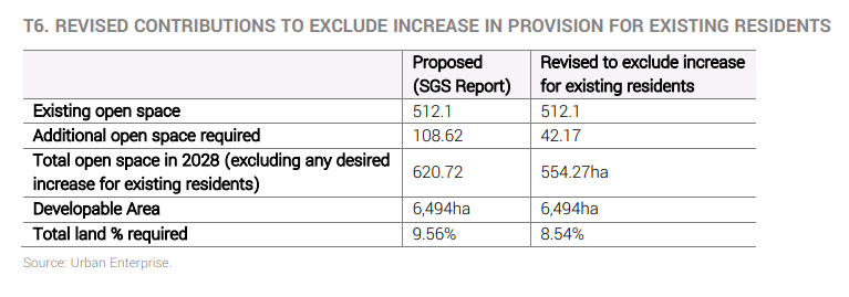
Table below shows that of the 108.62 additional hectares of open space that the SGS report identifies as needed to achieve the target provision of 30qm per resident in 2028, 66.45 ha (61%) relates to the amount of additional land required to increase the provision of open space per existing resident.
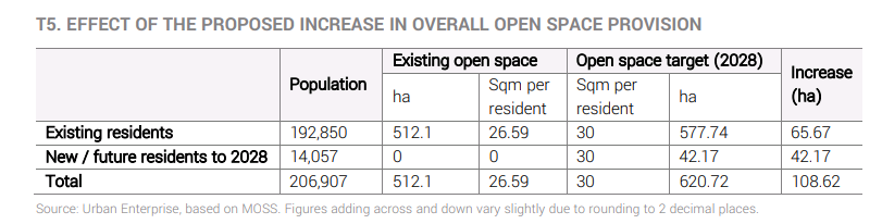
Mr Ainsaar believes it is inequitable for new development to be required to make a contribution to open space which is calculated on the basis of increasing the provision of open space for existing residents. If the method were to be recalculated to exclude the targeted increase in open space for existing residents, the outcome would be maximum contributions rate of 8.54% as show in the table below
The suitability of the provision standard of 30sqm per person for future subdivision town planning permits
Mr Ainsaar argues the Amendment relies on an open space provision target of 30sqm per resident which the Explanatory Report notes is “consistent with the provision of open space required in the planning for new housing in Melbourne’s growth areas”.
In his opinion, the Amendment adopts an overall open space provision target that is high relative to recently approved strategies and Precinct Structure Plans and which has insufficient regard to the population density and accessibility.
The SGS report shows that the provision target has been derived from a range of local, national and international examples which generally range from 20sqm to 30sqm per capita. The SGS report also notes that “A number of Melbourne based local governments apply a per capita provision rate to determine open space standards, and typically range between 24 and 30.3 square metres per capita.”
Mr Ainsaar reviewed the open space provision targets for four recent established area open space strategies in Melbourne, and four recently approved Precinct Structure Plans in Melbourne’s growth areas.

The provision standard adopted for Monash of 30sqm per resident is considerably higher than that recently adopted for activity centres in Kingston and Manningham (10sqm per resident) and is higher than the open space provision rate in recent growth areas (which ranges from 19sqm to 23sqm per resident).
Giving consideration to population densities increase, the provision of a specified quantity of open space per resident becomes less practical. Using Fishermans Bend as example, the open space strategy “sets a target of nine square metres per resident and worker, based on recommendations of the World Health Organization” The Planning Review Panel found that “The proposed quantity and distribution of open space in Fishermans Bend is broadly acceptable”. If a standard of 30sqm per resident were to be provided in Fishermans Bend, the 80,000 residents would require a total of 240 hectares of open space. This would take up more than 70% of the Net Developable Area in Fishermans Bend (340ha) which is clearly not a feasible outcome.
In his view, the selection of an open space provision target, if applied, should have regard to:
- The existing provision of open space;
- The existing and proposed population density; and
- A concurrent target relating to accessibility, so as not to solely rely on a quantitative target.
In the evidence statement prepared by Matt Ainsaar, he further points out Jells Park is one of the largest open spaces in the municipality, however this major park has been deducted from the calculation of open space provision per resident on the basis that it is classified as a regional open space. When Jells Park is included in the open space provision, the existing provision of open space per capita increases from 27sqm per resident to 41.25sqm per resident. This rate of provision comfortably exceeds Council’s own planning benchmark of 30sqm per resident. Despite not being a Council-owned open space, residents across the municipality, and especially in the eastern part of Monash, will clearly benefit from the availability of passive recreation opportunities in Jells Park and the broader Dandenong Valley Parklands. In his view, it is misleading to exclude Jells Park from the calculation of open space per resident.
Equity of applying the same rate to subdivision in all land uses
The Amendment proposes to apply a single open space contributions rate to all precincts across the municipality and all land uses, including residential, retail, commercial and industrial.
This would mean that, for example, an industrial subdivision in Mount Waverley would make the same contribution (in percentage terms) as a residential subdivision in Clayton.
The open space target on which the contributions rate is calculated relates solely to open space per resident. Although it is common for open space strategies to express open space provision in terms of provision per resident, in practice the open space also services workers, albeit in a different way
In his view, it is entirely inequitable for employment land uses to be required to make a contribution to public open space equivalent to 10% of the land area or site value when:
- The need for open space has not been demonstrated in the supporting material; and
- There is consistent evidence which demonstrates that the quantity of open space required to meet the needs of workers is considerably less than the quantity needed for residents.
Across Wyndham and Casey, open space contributions in employment areas are generally between 1.6% and 3.1%. In the municipalities of Brimbank and Greater Dandenong where there is considerable land for employment purposes, a lower contributions rate is applied to industrial (2% or 2.5%) than is applied to residential development (5%) as part of a municipal-wide approach to contributions.
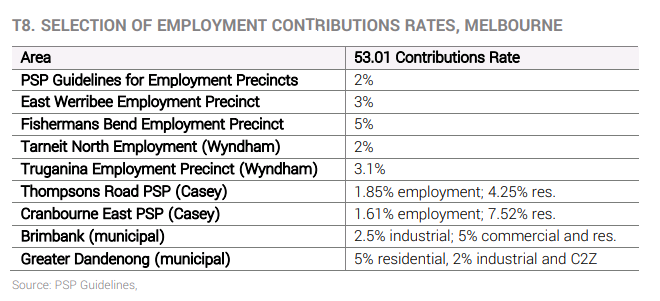
In his view, the MOSS does not provide sufficient justification to support the application of a very high rate of 10% to employment land in the municipality.
An alternative way forward
Mr Ainsaar concludes that the proposed rates should be set aside and replaced through a more robust, suitable and equitable method of calculating the contributions rate for subdivision. The Panel should also consider:
- There is no justification in the material supporting the Amendment for a public open space contributions rate for residential development higher than 5%; and
- The contribution for employment land uses should be lower than the rate for residential development – a contribution in the order of 2-3% would be appropriate.
Panel Hearing and other Evidence Statements
The independent planning panel hearing takes place from Monday 17 February 2020 and will go for 4 days.
City of Monash will present on day 1 and other parties to present on day 2 to day 4.
More information about the amendment, including the amendment documents and other evidence statements are available on the City of Monash website.
IBAC is holding public examinations into allegations of serious corrupt conduct in relation to planning and property development decisions at the City of Casey council.
The City of Casey, in Melbourne’s south-east, is Victoria’s most populous local government area and one of the fastest growing in the nation. It is home to more than 340,000 residents and includes the suburbs of Berwick, Narre Warren and Cranbourne.
The examinations are part of an IBAC investigation, Operation Sandon, into allegations of corrupt conduct involving councillors and property developers in the City of Casey in Melbourne’s south-east. The initial phase of the public examinations ran from 18 November to 6 December 2019. Examinations will recommence on 2 March 2020.
For months the Independent Broad-based Anti-corruption Commission has been examining council decisions related to property development and planning in the City of Casey as part of Operation Sandon. It heard property developer John Woodman allegedly paid at least $1.2 million in bribes to former Casey mayors Sam Aziz and Geoff Ablett in a bid to win planning approvals for his clients.
There is widespread speculation that Casey Council are set to be sacked by the state government as early as this week when laws to sack the council could be introduced to Parliament when it sits on Tuesday, with two councillors resigning ahead of the likely purge. Councillor Timothy Jackson and Cr Rex Flannery resigned from their post on 14 Feb 2020.”I no longer hold confidence in council’s ability to exercise decision-making to the standard that our residents expect,” Councillor Timothy Jackson said in a statement.
What is the story?
Cranbourne West Rezoning
Casey Council originally opposed the proposed rezoning of the Cranbourne West Precinct from industrial to residential land in 2014, but backflipped and supported it in 2015.The rezoning would have increased the value of the land by more than $100 million for one of Mr Woodman’s companies, Leighton Properties. The proposal is still with Planning Minister Richard Wynne.
Hall Road intersection
At the hearing of IBAC, it was revealed Cr Aziz pushed for the immediate construction of an intersection at Hall Road at Cranbourne West, against the advice of the council’s planning officers.
IBAC said the acceleration of the project would have delivered “windfall profits” for the developer Wolfdene, for whom Mr Woodman was working as a consultant, by “enabling it to develop land well ahead of the time it otherwise would have been able to”.
Pavilion estate
An amendment was moved by Cr Aziz last year to reduce the amount of open space required at the Pavilion housing estate and increase the amount of land being developed by Woodman-linked company Wolfdene.
John Woodman
John Woodman has been a prominent Melbourne property developer since the 1980s. He’s accused of paying massive amounts of money to City of Casey councillors so they’d vote in favour of his planning decisions.So far, the inquiry has heard evidence Mr Woodman and his associated companies gave Casey councillors Sam Aziz and Geoff Ablett $1.2 million. The commission heard Mr Woodman held $600,000 cash which was delivered to him in a suitcase from Cr Aziz in 2017, which Mr Woodman returned with interest, totalling $822,000. Some of the money was returned through payments to the bank accounts of Cr Aziz’s family members or funds to pay off his tax debts.
Cr Sam Aziz
IBAC alleges councillor Sam Aziz received $900,000 in payments from Mr Woodman or his associated companies over several years. The inquiry heard he was paid $80,000 by companies linked to Mr Woodman for his advice on plans for a satellite city at Little River, west of Melbourne. Cr Aziz is currently in Egypt and IBAC told the inquiry it didn’t know if Cr Aziz would return to face public hearings. The inquiry heard he sold his house after police searched his property as part of the investigation a month ago.
Cr Geoff Ablett
IBAC says former Hawthorn premiership player Geoff Ablett, a current City of Casey Councillor, received more than $330,000 from Mr Woodman or his associated companies.
The inquiry heard he received thousands of dollars in payments from Mr Woodman funnelled through Victorian horse breeder, Spicer Thoroughbreds, without the knowledge of the company’s owner who said the payments were “totally unauthorised”. Cr Ablett also received $15,000 in bank transfers from Mr Woodman either unsigned or under a fake name to pay off his credit card debt in 2014, before he ran as a Liberal candidate for the seat of Cranbourne in the Victorian election. Mr Woodman also bought a share of Cr Ablett’s land in Mountain View in eastern Victoria for more than $300,000.
Lorraine Wreford
The former state Liberal MP and Casey mayor was hired by Mr Woodman as a political lobbyist and was paid $5,000 a month. The inquiry heard she was also promised a trip to Europe for her and her boyfriend if the Cranbourne West rezoning project was successful.
Ms Wreford would deliver bags of cash totalling more than $100,000 from Mr Woodman to Cr Aziz as interest payments, the inquiry was told. The inquiry also heard Mr Woodman would only speak to Ms Wreford in encrypted WhatsApp messages and IBAC accused Ms Wreford of behaving like a “drug dealer” using code words such as “the package” to refer to the payments. She also referred to Mr Woodman as “the blood donor” when discussing him with Cr Aziz, the inquiry heard.
The examinations are part of an IBAC investigation, Operation Sandon, into allegations of corrupt conduct involving councillors and property developers in the City of Casey. The initial phase of the public examinations ran from 18 November to 6 December 2019. Examinations will recommence on 2 March 2020. If there’s found to be evidence of corruption, IBAC can bring criminal proceedings against the parties involved and it can also refer the matter to the Office of Public Prosecutions.
Following the footsteps of Frankston City Council, who successfully increased their public open space contribution rates, Monash Council proposed amendment C148, an amendment that is much heavier handed and is one of the highest of any council.
Amendment C148 proposes to increase the public open space contribution requirement for subdivisions of 3 lots or more to 10% cash, 10% land, or a mix of both. Currently, Council requires a public open space contribution of between 2% and 5% depending on the number of lots created. A contribution rate of 10% has been determined by council as necessary to deliver a reasonable standard of open space provision across the whole of Monash for a growing population. Council believes this contribution rate reflects the need to ensure that all future residents will have contributed to providing an appropriate level of public open space services and recognises a need of 30 square metres per person as determined by Monash Council.
Recently, an independent Planning Panel has been appointed by the Minister for Planning to consider the Amendment and all submissions that Council received about the Amendment. The Planning Panel Hearing for the Amendment C148 will commence on Monday 17 February 2020 and will go for 4 days. With the hearing commencing shortly, Evidence statement prepared by Dr Marcus Spiller, instructed by Maddocks on behalf of the City of Monash, been released on the council’s website for public to inspect and review.
Dr Marcus Spiller is a Principal and Partner of SGS Economics & Planning Pty Ltd (SGS), with academic qualifications of PhD in Global Studies, Social Science and Planning, Master of Commerce (Economics) and Bachelor of Town and Regional Planning. Dr Spiller specialises in metropolitan strategic planning, housing policy, urban infrastructure funding and the links between urban structure and national economic performance. Dr Spiller also has experience in providing advice to all tiers of government and the private sector related to the dynamics of housing, transport, employment, infrastructure and the general economy in cities.
Why Council adopt 30 square metres of Open Space per person
In the evidence statement, Dr Spiller first explains the rationale behind the need of 30 square metres of public open space services per person as determined by Monash Council.

In the table above, provided by Dr Spiller, Melbourne based local governments illustrate a range of open space rate between 24 and 30.3 square metres per capita, while other average open space rates under a range of other authorities are slightly higher than 30 square metres per capita. Therefore 30 square metres of open space per capita is considered a reasonable benchmark to apply in Monash. Despite this rate is towards the higher end of the range of possibilities, the adoption in Monash is justified in the context of climate change and community expectations of greater infrastructure investment to support urban consolidation.
Dr Spiller further adds, as at 2016, open space provision across the whole of Monash stood at less than 27 m2 per capita, which is already 10% below the standard adopted above. With no further addition to open space stocks, the open space rate will fall to less than 25 m2 per capita over the next decade. Therefore Substantial investment in the quantity and quality of open space provision in Monash is required to arrest this trend decline and build towards a reasonable standard of sufficiency.
Why council propose flat rate of 10%
To arrive at the uniform 10% contribution rate for Monash, the open space standard has been applied to all developable land in the City; that is, including land already developedas well as land that is likely to be developed or redeveloped over the planning period. Conceptually, his calculation method contemplates Monash as a blank slate and poses the question ‘how much open space would be required in the City by 2028 to fulfill an aggregate provision standard of 30 m2 per capita?’ This quantum is then divided by all developable land to give a ratio.

Dr Spiller argues that a 10% contribution rate is not unprecedented. In his opinion, historic practices in open space contributions in metropolitan Melbourne are no longer appropriate in the context of climate change and community expectations for additional investment in infrastructure to support urban consolidation. Contribution rates under the open space Particular Provisions in Planning Schemes have been increasing in recent years, with a number now featuring flat rates of around 8% covering large areas of municipalities. He regard this as a reflection of growing awareness that “business as usual” in open space contributions will no longer do and that substantially increased investment in the quantity and quality of open space is a pre-requisite for urban consolidation and a climate resilient city.
Impact on development in Monash
Dr Spiller believes the cost of the increased open space contribution will most likely be passed back in the form of lower bid prices for development sites rather than compression of developer profit margins or increases in dwelling prices. In many circumstances, the reduction in bid prices for development sites will still leave a substantial premium for land sellers so that they will remain motivated to sell to bona fide developers. There is a large pool of potential development sites in Monash. Only a small proportion of these sites needs to be released for development to achieve projected housing demand.He believes developers who have already acquired land for development but have not yet subdivided will be impacted by the introduction of a higher open space contribution rate as it will not have been incorporated in initial development costs assessment. Am C148 will affect development feasibility to the extent that it influences the profile of costs that need to be built into the RLV calculation, in particular the public open space requirement.
Impact on housing affordability
It is his opinion that the Gross Realised Value (GRV) of developments in Monash will not be affected by the introduction of Am C148 as Developers operate in competitive markets and are unable to apply a cost plus formula to dictate unit sale prices. They are price takers rather than price makers.
Therefore, he disagrees with those who claim that increase in the open space contribution rate will lead to dwelling prices increases. These prices will be determined in the wider market independently from the open space provision requirements in the Planning Scheme. The increased open space contribution will impact on the price developers are willing to pay for a development site, not on the price that development units are sold for, nor on the construction costs.
Dr Marcus Spiller’s Conclusion
Am C148 is critical to ensuring there is adequate open space in the future. The proposed amendment to require all subdivisions of 3 lots or more to provide a public open space contribution of 10 per cent will enable an adequate funding stream for City of Monash to ensure there is a sufficient standard of open space provision.
He believes AM C148 will not impact on housing prices in new developments. It may have a short term impact on landowners’ willingness to sell due to a change in the profile of development costs which sees residual land value becoming a smaller proportion of the gross realised value. But it cannot be assumed that this will forestall development.
Panel Hearing and other Evidence Statements
The independent planning panel will commence on Monday 17 February 2020 and will go for 4 days. City of Monash will present on day 1 and other parties to present on day 2 to day 4.
More information about the amendment, including the amendment documents and other evidence statements are available on the City of Monash website.
The assessment of ‘neighbourhood character’ has been a long standing contentious issue in the assessment of planning applications. Recognising that this tension shows no sign of abating the state government recently released Planning practice notes PPN90 and PPN91 with the aim of guiding local council planning departments on best practice in how to prepare their planning schemes to accommodate housing growth in some areas, balanced with the protection of neighbourhood character in others.
Local council’s housing strategy is often accompanied by a neighbourhood character strategy along with other relevant strategic work such as heritage, landscape, environmental or land capability studies.
While a housing strategy identifies the extent and density of future housing, a neighbourhood character strategy assists in identifying valued characteristics of areas that need to be considered when identifying the preferred future character for residential areas. Actions can then be identified to ensure that existing character is respected, or a preferred new character is achieved. Conflict arises however when the housing strategy identifies a need for housing growth in a specific geographical area and the neighbourhood character strategy places an emphasis on retaining features such as ‘spaciousness’ and ‘large gardens’ in the same geographical area. The practice notes aim to resolve this inherit conflict that is created when these conflicting objectives make their way into planning schemes.
Role of local housing strategy:
- Ensures a range of housing opportunities are available across the municipality to meet the needs of the projected population
- Outlines the strategies and implementation mechanisms to accommodate the projected population and household needs
- Identifies where and how the housing needs of the future population will be met across the municipality
- Identifies suitable locations for housing growth including those areas close to services, jobs, public transport and activity centres, and strategic development areas.
Role of local neighbourhood character strategy:
- Considers both the public and private realms
- Provides strategic direction for neighbourhood character to guide future development through preferred neighbourhood character statements or neighbourhood character objectives
- Identifies the comparative significance of each neighbourhood character area. In assessing the significance of areas, comparisons need to be made, not only with other parts of the municipality but also with the wider region
- Forms the basis for neighbourhood character statements, policies, objectives and local variations to clause 54 and clause 55 being included in residential zone schedules, a Neighbourhood Character Overlay or other overlay.
Neighbourhood character is not a static concept, streets and neighbourhoods are dynamic places and evolve over time to meet modern living standards and architectural tastes. For example, respecting character does not mean protecting character in an incremental change area. If growth is earmarked for an area under the housing objectives then the preferred neighbourhood character statement should complement that objective by acknowledging change in the built form of streets is expected to occur.
To achieve this, DELWP suggests local councils to develop a residential development framework by feeding neighbourhood character strategy into local housing strategy which identifies minimal, incremental and substantial change areas; to balance the need to protect valued character with the need to ensure housing growth and diversity
What does ‘respect’ mean?
Respecting character does not mean preventing change. In simple terms, respect for the character of a neighbourhood means that development should be designed in response to its context.
Depending on the neighbourhood, there are two broad approaches for building designs to respecting character:
- Respecting the bulk and form of surrounding development
- Respecting the architectural style of surrounding development.
Respecting neighbourhood character does not mean mimicry and pattern book design or limiting the scope of design interpretation and innovation. Instead, it means designing the development in response to the features and characteristics identified in the neighbourhood.
What is preferred neighbourhood character?
Under clause 54 and clause 55, new development should respect the existing neighbourhood character or contribute to a preferred neighbourhood character.
Preferred neighbourhood character is either:
- The existing character of an area; or
- An identified future neighbourhood character different from the existing character of an area.
Where the existing neighbourhood character is the preferred neighbourhood character, it is important to identify the existing features and characteristics of the area to be respected. This is something local council planning departments need to focus on.
Preferred neighbourhood character statements
The planning practice notes suggest councils to produce preferred neighbourhood character statements for each municipality. A preferred neighbourhood character statement can articulate the valued features and characteristics of an area to be respected by new development and these statements should be ‘forward-looking’ so that if an area is identified for increased housing growth, the growth is not undermined by neighbourhood character policies that seek to maintain the existing neighbourhood character.
Identifying change areas
The Planning practice notes place emphases on council to clearly distinguish and define minimal, incremental and substantial change areas.

Minimal change areas
Minimal change areas have characteristics that are ‘sufficiently special’ to a municipality, metropolitan Melbourne or Victoria, and should be protected because of their special neighbourhood, heritage, environmental or landscape characteristics.
Minimal change areas can also be areas that are constrained by planning considerations such as the physical capability of the land to safely accommodate more residential development. For example, restricting additional housing in areas close to airports, land subject to bushfire risk, flooding or erosion.
Minimal change areas should not be identified based on remoteness from activity centres, jobs, services or transport, or because single-dwelling covenants or other restrictive instruments exist.
Minimal change areas may appear differently in different built form contexts. For example, inner city heritage terraces and large lots with landscape values may both be considered minimal change areas but are very different residential environments. In both cases, the special characteristics of each area is the principal input into whether they are categorised as minimal change.

Incremental change areas
Incremental change areas are where housing growth occurs within the context of existing or preferred neighbourhood character.
The built form context of incremental change areas can vary widely. For example, incremental change in an inner urban area can represent a very different scale of development from an incremental change area in an outer suburban area, or a regional town or city.
The key point is that incremental change is relevant to its context.

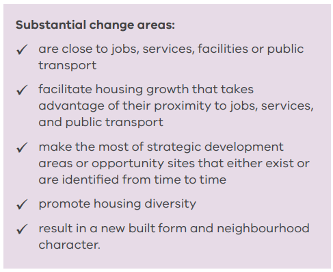
Substantial change areas
Substantial change areas are where housing intensification will occur that results in a substantially different scale and intensity of housing compared to other areas of a municipality. This may include areas in and around activity centres, along public transport corridors and strategic development areas.
Substantial change areas will reflect a different degree of change in different built form contexts. For example, a substantial change area in an outer urban and regional context may more closely resemble an incremental change area in an inner urban context.
Example of residential development framework

What does it mean for you if you are thinking of subdividing?
DELWP recognises the tensions between councils and developers around housing growth and neighbourhood character objectives. DELWP suggests local councils to develop a residential development framework which identifies minimal, incremental and substantial change areas; to balance the need to protect valued character with the need to ensure housing growth and diversity. These Planning practice notes will provide guidance to local governments on how to apply new zones and how to structure their local residential development framework.
What is most encouraging for those that are thinking of subdividing their property, is that these frameworks can provide certainty for the community about where changes are likely to occur as well as expecting in what form it will take.
With councils clearly outlining what is the definition of Preferred Characteristic for each area and what is meant by respecting the characteristic of an area in a Preferred neighbourhood character statements; applicants can design their subdivision project with confidence, knowing the chances of their application being refused by council because of not respecting the local preferred characteristic is much lower.
Port Phillip council is proposing Amendment C142 to its planning scheme that will see 140 new properties included within its heritage overlays.
The extension of the heritage overlays will now include properties that the council believe are ‘Significant’ or ‘Contributory’ heritage places, allowing for more planning controls on these properties.
The amendment expands the scope of both Heritage Overlay 6 (HO6) and Heritage Overlay 391 (HO391), broadening the buildings and streets that are included within them.
HO6 comprises St Kilda East bound by Wellington Street / Dandenong Road to the north, Orrong Road to the east, Argyle and Inkerman Street to the south and St Kilda Road to the west.
HO391 comprises Alma Road to the north, Alexandra Street to the east, Mooltan Avenue to the south and Hotham Street to the west.
14 Raith Court in St Kilda East will be removed from the heritage overlay.
The amendment is part of an on-going program by Port Phillip Council to review heritage precincts within the municipality in order to address what the council say are gaps in the current heritage precincts.
The council state in their explanatory report that the amendment updates overlays so heritage controls remain current and reflect best practice to assist in their conservation.
Port Phillip council has strict controls compared to other councils in Victoria, as a large part of the municipality is already protected by a number of heritage overlays.
The amendment can be read in full here.
What is a heritage overlay?
A heritage overlay is an area identified by councils to be protected due to the historical nature of certain buildings contained within. The overlay allows greater planning controls within an overlay to ensure that heritage buildings are conserved and that new development does not have a detrimental impact.
Amendment C142 to the Port Phillip Planning Scheme
Below shows the areas that will be affected by the amendment:

The amendment will affect homeowners and developers of newly included buildings as they will now have to apply for a planning permit for most buildings and works which means additional costs as well as added time to the development process.
There are three categorises of buildings in a heritage overlay:
Significant heritage places
These buildings and surrounds have the strictest controls as they are individually important places of either State, regional or local heritage significance. Some of these places may be listed on the State Heritage Register which requires approval from Heritage Council Victoria for any works or changes.
Contributory heritage places
These include buildings and surrounds that are heritage places of local significance which directly contribute to the significance of the Heritage Overlay. However they have less controls than significant heritage places.
Non-contributory properties
These are buildings that do not add to the heritage significance of an area but are included in a heritage overlay. These buildings are controlled under the overlay as any new development may impact the overall heritage significance of a place. They have the least controls as they do not directly contribute to the heritage of the area.
Do I need a planning permit to develop my property in a heritage overlay?
Buildings in heritage overlays require planning permits for a broad scope of works. This is to protect the heritage significance of the buildings and area.
Under the Heritage Overlay, a planning permit is required from the council to:
subdivide land
demolish or remove a building (including part of a building)
construct a building (including part of a building or a fence)
externally alter a building
construct or carry out works
construct or display a sign
externally paint an unpainted surface
externally paint a building if the painting constitutes an advertisement.
Other controls may also apply such as internal alteration controls and controls over trees.
Applying for a Vicsmart planning permit in a heritage overlay
However minors works such as external painting of a building or constructing a fence can usually be applied through a Vicsmart planning application.
These type of applications are approved in 10 business days and have significantly lower application fees than a regular planning permit application.
Buildings and works in a Heritage Overlay that can be applied through Vicsmart:
• External painting
• Construct a fence
• Construct a carport, garage, pergola, verandah, deck, shed or similar structure
• Construct and install domestic services normal to a dwelling
• Construct and install a non-domestic disabled access ramp
• Construct a vehicle cross-over
• Construct a domestic swimming pool or spa and associated mechanical equipment and safety fencing
• Construct a rainwater tank
• Construct or display a sign
• Lop a tree
• Construct or install a solar energy facility attached to a dwelling
• Construct and install an electric vehicle charging station
• Construct and install services normal to a building other than a dwelling, including chimneys, flues, skylights, heating and cooling systems, hot water systems, security systems and cameras, downpipes, window shading devices, or similar
The amendment will be independently assessed by a Planning Panel this month. The Minister for Planning will then decide whether to adopt the amendment into the Port Phillip planning scheme following on from the Planning Panel’s report.
Combustible cladding is a major issue throughout Victoria and the government have committed to fund works to remove unsafe cladding following hundreds of high risk building being identified.
In 2017 the Victorian Cladding Taskforce was set up to address the issue and established a state wide audit. To date the audit has inspected over 2,200 buildings across the state.
Of the buildings that have been inspected 1069 buildings have been found to have combustible cladding. 72 have been found to be an extreme safety risk and a further 409 buildings have been found to be a high safety risk.
The audit involves an inspection of a building, followed by an assessment by an expert panel who assign a risk rating to the building.
The Cladding Taskforce released a report this year with 37 recommendations to overhaul the state’s approach to cladding. It addresses the systemic issues that led to unsafe cladding being used and the need for regulatory building reform.
Cladding Safety Victoria
The recently established Cladding Safety Victoria is one of the key recommendations from the report. This governing body has been set up as a one stop shop to oversee the removal of combustible cladding and provide funding and support to owners.
Buildings which have been audited and found to be high risk are referred to Cladding Safety Victoria who organise the rectification works with the highest risk buildings being prioritized.
15 buildings have been identified as the most at risk and will have their cladding fixed first. This includes the Neo 200 complex on Spencer Street, Melbourne which caught fire this year and required more than 80 firefighters to put out the blaze.
However moderate to low-risk buildings will not be eligible for funding and it will fall on the owners to foot the bill for removing combustible cladding. The government have estimated it will take at least five years to complete the rectification works.
Three classes of buildings have been included in the audit all built after March 1997 when combustible cladding began being widely used:
• Class 2 buildings
Apartments that are three or more storeys.
• Class 3 buildings
Hotels, motels and student accommodation that are three or more storeys.
• Class 9 buildings
Hospitals, schools and aged care facilities that are two or more storeys.
The Victoria government has committed $600 million to help with the cladding crisis which will be delivered by Cladding Safety Victoria. However as the auditing continues more buildings will require funding to remove unsafe cladding and the cost to fix all high risk buildings has been estimated by some to run into the billions.
Increase cost of building permits
It was announced in July that $300 million of the $600 million state budget for the works will come from taxpayers. The government will make up the other $300 million shortfall through a levy on building permits on buildings which have a cost of works of more than $800,000. This is the result of the Federal Government’s refusal to contribute to the fund due to the cladding being deemed a failure by state building regulations, and therefore the state’s responsibility.
This will have a big impact on developers who will now have to pay higher fees for building permits. It has been estimated that the increase will apply to about six per cent of building permits but will exclude low-rise buildings such as single dwellings and townhouses. The Government is proposing a 700 per cent increase in the levy for new buildings valued at more than $1.5 million. For works around $800,000 the levy rate will double.
The Cladding Crisis
Combustible cladding has been used in the building industry in Victoria over the past 20 years mostly due to its low cost as well as its light weight and insulating properties.
There are two types of cladding used on buildings that have been found to be flammable. These are aluminium composite panels or ‘ACP’ and expanded polystyrene or ‘EPS’. These types of cladding escalate fires quickly and cause them to spread.
The dangers of cladding were brought to public attention in Victoria following the 2014 fire at the Lacrosse building in Docklands. It was the first major building fire in Victoria caused by combustible cladding.
However this was only the start of concerns as in 2017 the Grenfell tower fire in the UK claimed the lives of 72 people. This put major pressure on Governments to tackle the problem and was a wakeup call for the Victorian State Government who the same year introduced their Cladding Taskforce.
How to find out if your building has combustible cladding
If you want to know if your building has combustible cladding speak to the owner’s corporation or building manager who will be able to confirm if the building has been audited and what the results were.
You can look up the number of buildings with combustible cladding in your municipalityhere. If you are looking at purchasing an apartment or building VBA have released a fact sheet to help.
The Victorian Government have also announced they will be undertaking a review of the state’s Building Act to identify what legislative changes are required to better protect consumers.
Cladding Safety Victoria have released a list to improve safety measures in buildings; such as:
• installing smoke alarms
• fixing/unlocking emergency exits
• removing ignition sources
• Steps you can take to reduce the risk from cladding
• Extinguish cigarettes safely
• Keeping hallways clear to avoid obstructing occupants needing to exit the building
• Not covering air-conditioning units with clothes or other materials
• Keeping balconies clear of clutter and material such as clothing, boxes or rubbish
• Ensuring barbecues and heaters are not used near combustible material.
• Ensuring smoke alarms inside apartments are not covered or disconnected
• Keeping fire stairwells and landings clear and not to store items within them
If you are an owner or owners corporation you are also legally required to:
• Ensure the alarm and fire extinguishers have been maintained
• Keep fire doors clear of obstructions, closed and unlocked at all times
• Ensure all occupiers know the building’s evacuation plan and fire safety procedures
The Better Apartments in Neighbourhoods Discussion Paper 2019 has been released by the Victoria State Government DELWP. It is proposing several recommendations for apartment developments which will improve their design and liveability for residents and the neighbourhood in which they are built.
Apartments are an essential part of residential development in Victoria helping with the pressures from an ever increasing population and creating affordable housing. It is forecast that by 2051, Victoria’s population will increase by over four million people with an estimated 1.9 million additional households.
The DELWP is asking for feedback on the changes from the Victorian public who can make a submission to them online. The proposed changes outlined in the paper will only affect apartment buildings which are identified as residential developments five or more stories high.
In 2017 the Victoria Government introduced the Better Apartments Design Standards which was a response to concerns that apartments were ‘not providing safe and healthy environments.’
Victoria’s Better Apartments Design Standards are implemented in all planning schemes across the state through the Victoria Planning Provisions (VPP).
This Discussion Paper is a continuation of this to further improve apartment design and development.
What are the new changes to apartments?
There are five new measures that are proposed to improve apartment developments in Victoria which include: green space, wind effects, appearance of apartment buildings, street interface and constructions impacts.
Below is a summary of the proposed new standards:
Green Space
The discussion paper outlines the need for improved landscaping and more communal green space in apartment buildings. The paper acknowledges that landscaping is often an afterthought and is not being utilized effectively. It also notes that landscaping is often limited along the front of apartment buildings which causes a less attractive streetscape. Currently, smaller apartment do not have a communal green space requirement, leaving a lot of residents without gardens. Only apartments with 40 dwellings or more need to provide open communal space of 25m2 as a minimum, smaller apartment developments have no obligation to do so.
Recommended changes:
- Encourage landscaping in street frontages
- Clarify current landscaping objectives and encourage more canopy tress as part of the landscaping
- Remove the threshold so all apartments will have a mandatory communal open space for residents of at least 25m2.
- A planning permit condition about how the landscaping will be maintained.
Wind effects
Presently there are no specific planning requirements to manage wind effects caused by a development. It is noted that tall buildings can increase wind which in turn can cause safety and amenity hazards for the public.
Recommended changes:
- Ensure wind effects are considered when developing a site
- Define comfortable and unsafe wind conditions to assess wind affects
- Clarify when a desktop wind study or wind tunnel analysis may be required
Appearance of apartment buildings
In inner cities areas such as central Melbourne apartments are very common and therefore design and development controls apply helps control the external look of buildings. However these controls are not applied in more suburban areas where apartments are now becoming increasingly popular. The changes will address the lack of external building controls in these less central areas of Victoria and make sure apartments are built with durability, attractiveness and easy maintenance in mind.
Recommended changes:
- New standard to require apartments to have a visually interesting, high-quality external design with external materials that are durable.
- New standard for apartments to have external walls that are accessible for maintenance.
Street Interface
Apartment buildings can often create poor street interfaces, which undermine safety and detract from the look and feel of a street. The current Better Apartments Design Standards do not sufficiently emphasise the need for street interface design to integrate building services and the other functional requirements of an apartment building. The proposed changes will help apartments better integrate with the surrounding streetscape and be more attractive to the public.
Recommended changes:
• Integrate the layout of developments with the street and encourage active street-level frontages
• Minimise the impact of vehicle crossovers and access points on the streetscape
• Ensure site services are accessible, adequate and attractive.
Construction Impacts
It is noted in the discussion paper that apartments often take a long time to build which causes several issues in the surrounding neighbourhood which need to be managed correctly. These include traffic, road and footpath closures, dust, odour and noise emissions. Currently construction issues are managed by individual councils and there is no clear consistency in the best practices.
Recommended changes:
•Developers will have to identify how they will manage and mitigate issues for the surrounding area caused by the construction.
•Suggested condition of a planning permit for developers to submit a construction management plan to be approved by council.
What affect will these changes have?
The proposed changes will have an effect on development costs of new apartment buildings particularly the green space requirement as all developers will be required to incorporate communal green space into their design. This means more expense when developing new apartment buildings which in turn will affect the affordability of apartments. However to what extent these changes will have an effect remains to be seen. Overall it will improve the amenity of apartment buildings for residents with more communal spaces, make apartments less of an eyesore in neighbourhoods and will alleviate tensions between developers and local residents during the construction stage.
What happens now?
All Victorians are invited to make a submission to the DELWP regarding the proposed new measures which can be made online via an online submission form. Submissions close on Friday 27 September 2019 at 5 pm. DELWP will consider the submissions when making recommendations to the Planning Minister.
An extensive report has been published into planning permit applications throughout seven councils to help improve the application process and avoid delays for developers. The Growth Area Councils Permit Assessment Health Check Report has looked at seven growth area councils to understand how they are performing when it comes to processing planning permit applications. The health check report said it will allow councils to ‘make good decisions; faster.’
The report was undertaken as part of the Streamlining for Growth Program funded by the Victorian State Government and managed by the Victorian Planning Authority (VPA).
What are growth area councils?
Growth areas are municipalities that have been identified as areas intended for increased development and expansion of housing and infrastructure. Growth area planning is unlike other planning permit processes as they are primarily applications for multiple lot subdivisions. These types of projects require developers to enter into an agreement with council to provide certain public assets in order to complete the subdivision of their lots. The public assets include roads, essential services, open space, drainage infrastructure among others. This is to make sure that the area can accommodate the increase in housing and people that the subdivisions create. However developers are concerned over long approval times along with inconsistences within the seven council’s processes.
The seven growth area councils in the report are: Casey, Cardinia, Hume, Melton, Mitchell, Whittlesea and Wyndham
The Report
The report gathered both qualitative and quantitative data giving a comprehensive insight and ‘nuanced narrative’ into how efficiently planning applications are processed throughout the councils. The report recognises how planning permits in growth areas are becoming increasing complex due to the amount of internal departments and external referrals that are involved.The report found all seven council follow the same overall structure when it comes to the planning permit process. However there were many differences in how the councils operate throughout the process. It looked at the whole planning process from pre-application all the way through to the statement of compliance and approval from council.
The Four Key Benchmarks for planning permit application.
Four key benchmarks where used to evaluate each councils strengths and weakness and see how they compare with each other.
- Scale + Maturity
This benchmark looked at the scale of growth of each of the councils along with the length of time they have been a growth area council.
All the councils were found to have an increasing growth in scale. Cardinia, Mitchell are both newly emerging growth areas and along with Hume will have a big increase in growth putting pressure on these councils, with the rest continuing to grow at a steady pace. Casey and Wyndham are the most longstanding growth councils with Casey reaching its peak volumes of growth.
- Communication + Culture
This benchmark looked at how councils work internally to reach planning application decisions and how they interact externally with developers.
Melton was found to have the highest level of openness and transparency both within their council and externally with developers. Hume had the lowest levels both internally and externally. Casey and Whittlesea where second highest with Cardinia, Wyndham and Mitchell coming in third.
- Process
This benchmark looked at approval timeframes at different stages of the assessment process. Along with how comfortable councils are at adapting processes and accepting risk to achieve better development outcomes.
The results found Hume was the slowest at processing planning applications of all the councils along with Wyndham, Whittlesea and Mitchell all having slow approval timeframes. Cardinia had the overall best approval times with Casey and Melton being middle of the range.
Wyndham have the strictest approach to planning permit applications making them less likely to be open to different types of developments followed by Hume then Casey. Melton is the most open and adaptable but will start to become stricter due to their past flexibility being ‘exploited by developers’. Cardinia is the second most open and flexible with planning applications along with Melton and Whittlesea both coming in third out of the seven councils.
- Resources
This benchmark considered the resources Councils have at their disposal when processing planning permit applications. This included the number of employees and their roles within growth area departments and the current technology used by council when processing planning applications.
Melton, Whittlesea and Wyndham were found to be well resourced but both Whittlesea and Wyndham were currently working at capacity for their planning applications. Casey has a ‘relatively lean team of officers’ but a ‘well-developed organisational structure.’ Hume’s small team were found to be stretched by the volume of applications and growth of the area. Cardinia was found to be a small but effective team that would benefit from more resources. Mitchell currently has the smallest growth area planning team consisting of a single statutory planner and an engineer. But as they are transitioning to a ‘fully-fledged growth area council’, they are investing in a bigger team of staff. Casey and Cardinia were found to be the most technologically progressive of the seven councils and Melton and Whittlesea the least.
The report also identified 5 key themes that are causing issues and delays during planning decisions throughout the seven councils which include:
- Growth area planning is not a standard planning permit assessment process asdevelopers are delivering public assets which make them more complex to assess
- There is a disconnect in expectations between the development industry and Council
- Lack of space for genuine negotiation and compromise between council and developers.
- Technology barriers at organisational level during the application process
- Skills and expertise shortage in councils
There are seven stages of a growth area planning permit application which include:
- Pre-application
- Referrals and Further information
- Permit assessment
- Certification
- Plan approvals
- Statement of compliance
Key areas of planning application delays were identified as the ‘Referrals and Further Information’ and ‘Planning Approvals’ stages as: “These stages require consultation with and negotiation between a range of internal and external parties before arriving at a decision.”
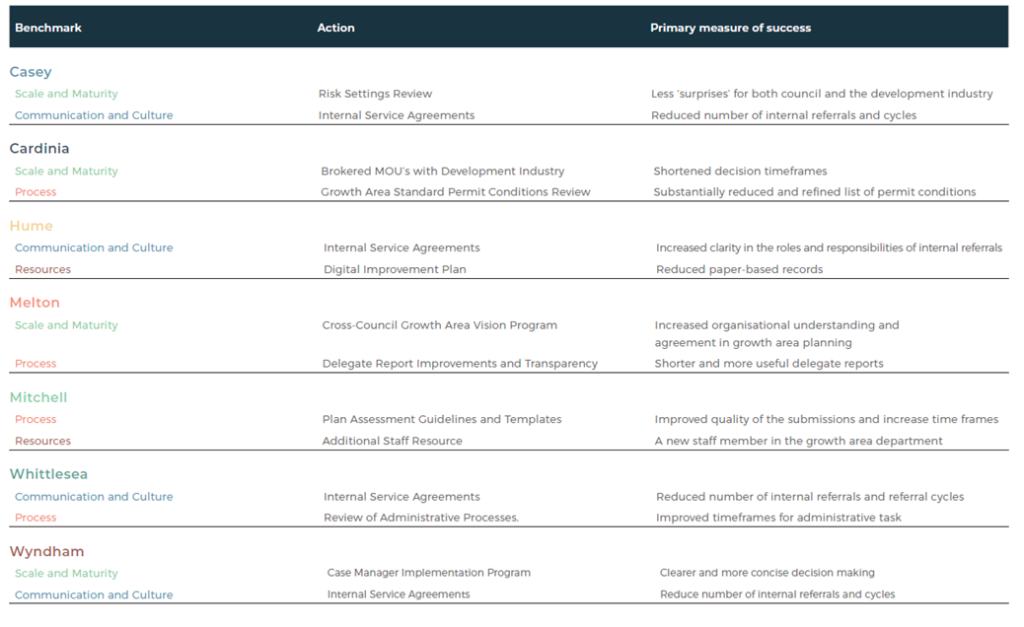
Action Plans
A general action plan was created for all seven councils along with individual actions plans for each of them. These include clearly outlined objectives that are to be met along with measures of their success.
“The action plans developed for each council seek to address the causes of these delays, by improving transparency, clarifying roles and expectations of various parties, and building a greater sense of trust between councils and the development industry. Some actions are best undertaken as a collective of growth area councils, whilst others are best undertaken by the individual council,” said the report.
Two actions have been chosen by each council as a priority from their biggest weakness identified by the four benchmarks. These can be seen below and were taken from the full report which can be found here.
What does this mean for planning permit applications?
This report along with the action plans it has produced will no doubt create more transparency and cohesion within the councils and with developers during the application process. It is an extensive report which, if the action plans are followed, will help developers and council achieve better outcomes and faster application times for planning permit application in these growth areas.