Planning Minister, Richard Wynne, announced some upcoming new standards for apartment design in Victoria on Sunday February 28th. The new standards will become part of Clause 55.07 – Apartment Developments and the particular provision at Clause 58 – Apartment Development.
Similar to the state’s first set of apartment standards introduced back in 2016 , these guidelines don’t mandate minimum lot sizes in the way that New South Wales’ SEPP 65 code does. The new standards focus on new landscaping standards to boost green space in and around apartment buildings, requirements for more deep soil planting to encourage canopy tree growth and the need for durable facades that will retain their aesthetics for longer.
Although the new standards are not facing as much opposition from developers as the first set of rules did back in 2016, it is expected the 2021 guidelines will again raise the costs for developers and buyers. Developers will be required to allow for more areas for landscaping as well as using more expensive and durable materials in residential developments. Property Council of Australia’s Victoria executive director, Danni Hunter, welcomes the new standards and said “We’re using our homes and our apartments as rest and exercise space and as a workplace, design has to be really flexible and adapt to what purchasers are telling us they want”.
Under the new rules, any apartment building with more than 10 residences must provide communal spaces, such as a barbecue area or seating, giving residents access to fresh air and apartment buildings taller than five storeys will be required to avoid “wind tunnelling” through sensitive design, and balconies will be eliminated on buildings taller than 40 metres to reduce overshadowing and “windswept” and underused balconies.
Not all developers were so welcoming of these new standards. “The industry remains concerned that the rigid application of these guidelines will lead to increasing construction costs that will erode project viability and ultimately lead to reduced housing supply and housing affordability,” the Urban Development Institute of Australia’s Victorian president and developer Ashley Williams said.
The full list of new standards is yet to be release. The draft version of the rules can be found here.
Following the illegal demolition of a heritage listed building in 2016 (Read article here), the Victorian Government is planning to introduce a piece of legislation which could stop development on a property for up to a decade if heritage buildings are illegally demolished.
The proposed legislation will cover buildings that have been unlawfully demolished, either in full or in part, and where the owners have been charged with unlawful demolition. Victorian Planning Minister, Richard Wynne, said the legislation is targeted at developers who plan to illegally demolish buildings and expecting to reap windfall gains from just selling or rebuilding on their land.
The legislation was prompted by the unlawful demolition of the 160-year-old Corkman Irish Pub in Carlton in 2016. The Corkman Pub, formerly known as the Carlton Inn Hotel, was built in 1858. Although it was not on the Victorian Heritage Register, it was covered by a heritage overlay. It was demolished over a weekend in 2016, a week after a fire was lit inside the building. The developer was later jailed for a month and ordered to pay more than $400,000 in fines and legal costs.
Victorian Planning Minister, Richard Wynne, said the illegal demolition of the Carlton Inn Hotel was “unprecedented in planning in the state of Victoria” and strong action to protect heritage buildings was needed.
The proposed legislation will also enable existing permits to be revoked and allow for new permits to be issued for specific purposes, such as building a park or reconstruction or repair of the heritage building. These new provisions are a significant strengthening of the current enforcement regime and are expected to act as a powerful deterrent to the unlawful demolition of buildings of heritage significance.
The minister also said the reform complemented measures that the Government introduced in 2017, which made it an indictable offence for a builder or person managing building work to knowingly carry out works without a permit or in the contravention of the Building Act, the regulations or their permit.
Melbourne is home to many heritage buildings and present major hurdles for planning applications. On a separate planning matter relating to planning applications affected by heritage overlays, St Vincent’s Hospital recently lodged plans to demolish the building the corner of Victoria Parade and Nicholson Street, a building that overlooks Carlton Gardens. While the building will not be illegally demolished, the hospital plans to replace it with a new 11-storey tower with glass façade with parts of the original façade at Daly Wing and Brenan Hall retained. The proposal already raising concerns that it would impact the World Heritage value of the Royal Exhibition Building moments after lodging the plans to City of Yarra Council. For the full article, click here.
It is commonplace for land owners to consider ‘heritage overlays’ and ‘heritage listings’ as significant barriers to the development potential of sites. While there is credence to this belief, it is not true to say that just because a property has some form of heritage control that the site is undevelopable and demolition is not possible. In an article produced by our team, we look at the town planning heritage controls that can affect a site and describe the likely implications of each for the development potential of the site. If you would like to know more about how to deal with ‘heritage overlays’ and ‘heritage listings’ in a planning permit application.
On 1 Feb 2021, the Victorian government announced a prohibition on the use of high risk cladding products on new multi-storey buildings, effective on the same day.
Minister for Planning, Richard Wynne, announced the prohibition on flammable aluminium composite panels (ACP) and rendered expanded polystyrene (EPS) as external wall cladding on all future multi-storey developments within Victoria.
The ban will prohibit the use of these high-risk products on apartment buildings, and other residential buildings such as hotels and aged care facilities with two or more storeys. The ban also extends to office buildings, shopping centres or other retail premises, warehouses, factories and car parks with three or more storeys.
The aim of the ban is limit the potential risk to the public from any future inappropriate use and reduces the risk of cladding fire incidents follow the incidents at Grenfell Tower, London in June 2017 and Neo200 building in Melbourne CBD in February 2019.
Both of these buildings were covered in aluminium composite panels (ACP). Investigations were conducted to examine why fire spreads so quickly when these claddings ignites, the article can be found here.
According to the media release, published by the Premier of Victoria, the Government also commissioned a cost benefit analysis, which found the ban will result in a net economic benefit of approximately $1 million annually due to reduced professional indemnity insurance costs. Building surveyors are responsible for signing off on buildings and it is required that a register building surveyor must have professional indemnity insurance, without any exemptions. However, after the cladding crisis, majority of the insurance underwriters no longer provide such cover, meaning building surveyors needed to pay premium in order to stay registered.
As part of the announcement, the Victorian Building Authority will be given extra power to enforce the cladding ban in its role as Victoria’s building regulator. Building companies that breach the ban will be fined up to $400,000 and Individuals can be fined up to $80,000.
Back in July 2019, the Victorian Government already established a $600 million Cladding Rectification Program to enable rectification of hundreds of buildings identified through the State-wide Cladding Audit conducted by the Victorian Building Authority and as part of the program, the Victorian Cladding Taskforce recommended prohibiting the use of combustible cladding in multi-storey buildings. Since the recommendation was made, the government conducted a five-month consultation process with the industry last year on the proposed ban. It is expected by the government that the building industry will not oppose to the new rules.
The new rule introduced will not dramatically affect the town planning aspects of developments within Victoria. Most likely effect on current town planning applications will be local councils issuing request for further information, requesting for changes in the material schedule. For the permit approved development, the responsibility of enforcing the ban will lie with the building surveyors.
More information about the specific cladding products and technical information about the risk posed by their inappropriate use can be found here.
On 23rd Dec 2020, Amendment GC172 was approved by the Minister for Planning and was published on the Government Gazettal, marking the end of building height inconsistencies in residential zones across Victoria which was caused by the Amendment VC110 in 2017.
Back in 2017, Amendment VC110 was introduced to strengthen building height controls in the Neighbourhood Residential Zone (NRZ) and General Residential Zone (GRZ), by introducing a mandatory default maximum building height requirement of:
- 11 metres and 3 storeys in the GRZ; and
- 9 metres and 2 storeys in the NRZ.
At the time of approval of VC110 amendment, local councils of Ararat, Boroondara, Greater Geelong, Glen Eira, Knox, Melbourne, Queenscliffe, Wellington and Whitehorse had lower maximum building height in a local schedule to a zone compared to the VC110 amendment. This resulted in these councils of Victoria having a maximum building height specified in a schedule to a residential zone that is lower than the maximum building height specified in the reformed residential zone.
For example, a building height lower than 9 metres specified in a Neighbourhood Residential Zone schedule and a height lower than 11 metres specified in a General Residential Zone schedule at the date the reformed residential zones came into operation under Amendment VC110 on 27 March 2017.
To rectify the discrepancies, Amendment GC172 was prepared by the State Planning Service of the Department of Environment, Land, Water and Planning (DELWP) with the following changes:
Ararat Planning Scheme
- Amends Neighbourhood Residential Zone – Schedule 1 (NRZ1) to modify the maximum building height from 8 metres, to 9 metres and 2 storeys.
Boroondara Planning Scheme
- Rezones land of specific areas from the General Residential Zone – Schedule 1 (GRZ1) (except land affected by Design and Development Overlay – Schedule 1 (DDO1)) to Neighbourhood Residential Zone – Schedule 1 (NRZ1) to retain the maximum building height of 9 metres.
- Amends General Residential Zone – Schedule 1 (GRZ1) (land affected by Design and Development Overlay – Schedule 1 (DDO1)) to modify the maximum building height from 9 metres, to 11 metres and 3 storeys
- Amends General Residential Zone – Schedule 2 (GRZ2) to modify the maximum building height from 10.5 metres, to 11 metres and 3 storeys.
- Amends General Residential Zone – Schedule 3 (GRZ3) to modify the maximum building height from 10.5 metres, to 11 metres and 3 storeys.
- Amends Clause 21.01-3, Clause 22.02-3 and Clause 22.05-5 to make consequential changes to the strategic framework plan and the content of the clause to be consistent with the reformed residential zones.
- Amends clauses 21.05-1 and 21.05-4 to make consequential changes to Table 1 and the housing framework plan to be consistent with the reformed residential zones.
Glen Eira Planning Scheme
- Amends General Residential Zone – Schedule 1 (GRZ1) to modify the maximum building height from 10.5 metres, to 11 metres and 3 storeys.
- Amends General Residential Zone – Schedule 2 (GRZ2) to modify the maximum building height from 10.5 metres, to 11 metres and 3 storeys.
- Amends General Residential Zone – Schedule 3 (GRZ3) to modify the maximum building height from 10.5 metres, to 11 metres and 3 storeys.
Greater Geelong Planning Scheme
- Rezones land of specific areas from the Residential Growth Zone – Schedule 2 (RGZ2) to General Residential Zone – Schedule 4 (GRZ4) and modifies the maximum building height from 10.5 metres, to 11 metres and 3 storeys
- Rezones land of specific areas from the General Residential Zone – Schedule 2 (GRZ2) to Neighbourhood Residential Zone – Schedule 8 (NRZ8) to retain the maximum building height of 9 metres.
- Amends Clause 21.06-3 to make consequential changes to the content of the clause to be consistent with the reformed residential zones.
Knox Planning Scheme
- Rezones land of specific areas from the General Residential Zone – Schedule 2 (GRZ2) to Neighbourhood Residential Zone – Schedule 4 (NRZ4) to retain the maximum building height of 9 metres.
- Rezones land of specific areas from the General Residential Zone – Schedule 5 (GRZ5) to Neighbourhood Residential Zone – Schedule 5 (NRZ5) to retain the maximum building height of 9 metres.
- Rezones land of specific areas from the General Residential Zone – Schedule 6 (GRZ6) to Neighbourhood Residential Zone – Schedule 6 (NRZ6) to retain the maximum building height of 9 metres.
- Amends General Residential Zone – Schedule 3 (GRZ3) to modify the maximum building height from 9 metres, to 11 metres and 3 storeys.
- Amends Neighbourhood Residential Zone – Schedule 1 (NRZ1) to modify the maximum building height from 8 metres, to 9 metres and 2 storeys
- Amends Clause 21.06-6 to make consequential changes to the content of the clause to be consistent with the reformed residential zones.
Melbourne Planning Scheme
- Rezones land of specific areas from the General Residential Zone – Schedule 2 (GRZ2) to Neighbourhood Residential Zone – Schedule 3 (NRZ3) and modifies the maximum building height from 8 metres, to 9 metres and 2 storeys.
- Rezones land of specific areas from the General Residential Zone – Schedule 4 (GRZ4) to Neighbourhood Residential Zone – Schedule 4 (NRZ4) and modifies the maximum building height from 9 metres and 10 metres, to 10 metres and 2 storeys
- Amends Neighbourhood Residential Zone – Schedule 2 (NRZ2) to modify the maximum building height from 8 metres, to 9 metres and 2 storeys.
Queenscliffe Planning Scheme
- Amends General Residential Zone – Schedule 1 (GRZ1) to modify the maximum building height from 8.5 metres, to 11 metres and 3 storeys.
- Amends Neighbourhood Residential Zone – Schedule 1 (NRZ1) to modify the maximum building height from 8.5 metres, to 9 metres and 2 storeys.
- Amends Neighbourhood Residential Zone – Schedule 2 (NRZ2) to modify the maximum building height from 6 metres, to 9 metres and 2 storeys.
Wellington Planning Scheme
- Amends Neighbourhood Residential Zone – Schedule 1 (NRZ1) to modify the maximum building height from 4.5 metres, to 9 metres and 2 storeys.
Whitehorse Planning Scheme
- Amends General Residential Zone – Schedule 2 (GRZ2) to modify the maximum building height from 10.5 metres, to 11 metres and 3 storeys.
- Rezones land in the General Residential Zone – Schedule 6 (GRZ6) to Neighbourhood Residential Zone – Schedule 8 (NRZ8) to retain the maximum building height of 9 metres.
- Amends Clause 21.06-9 to make consequential changes to the housing framework plan to be consistent with the reformed residential zones.
The full gazetted Explanatory Report can be downloaded here.
The planning scheme controls maximum building heights throughout Victoria. The amendment GC172 ensures that there is consistency and certainty about maximum building heights through the reformed residential zones. The department hopes this will improve the usability of the affected planning schemes and provides greater certainty for landowners and the community with respect to consistent use and application of residential zoning tools across Victoria.
How does this amendment affect land owners?
Although Amendment GC172 seems to be simply rectifying the oversight caused by Amendment VC110 back in 2017, the Devil is in the details and GC172 may have a material impact on land owners in terms of development outcomes that can be achieved.
In areas such as Boroondara, Whitehorse, Melbourne, Knox and Greater Geelong, where some land are immediately rezoned from the General Residential Zone to Neighbourhood Residential Zone, whilst there are no reduction to the maximum height that can be achieved, it is important to note that the Neighbourhood Residential Zone has a maximum height limit of two-storeys whereas the General Residential Zone allows for height up to three-storeys.
Furthermore, the objectives of the Neighbourhood Residential Zone and General Residential Zone are clearly different in terms of the intensity of residential development that is expected.
Using Knox Planning Scheme as an example.
The objectives of General Residential Zone reads:
- To encourage development that respects the neighbourhood character of the area.
- To encourage a diversity of housing types and housing growth particularly in locations offering good access to services and transport.
Whereas the Objectives of Neighbourhood Residential Zone reads:
- To recognise areas of predominantly single and double storey residential development.
- To manage and ensure that development respects the identified neighbourhood character, heritage, environmental or landscape characteristics.
Given difference of the objectives, council planners may assess development proposals differently.
How does this affect current applications?
Amendment GC172 does not have transition provisions meaning the rezoning of residential land takes immediate effect. If there is an application for a three-storey development within the General Residential Zone, and the land has been rezoned to the Neighbourhood Residential Zone, then the application will now be assessed against the new zoning and it is likely the development would now be refused given it exceeds the mandatory height requirement of two storeys. On the flip side, if a permit was approved under Neighbourhood Residential Zone, the permit applicant can lodge a permit amendment to take advantage of the new zoning.
All the documents that are published on the Government Gazettal can be found here. If you require further information or have any queries in relation to the Amendment GC172 or any town planning matters, please feel get in touch with our team.
Subdivision has always been a popular method of releasing the financial equity in a property. It allows property owners to add another dwelling or even rebuild a number of townhouses on one block of land. In this article, we will explain what is the process involved to obtain Plan of Subdivision for the newly created dwellings, the final step of your subdivision project.
Before we get to the final stage of the process, it is important to ensure it is feasible to subdivide your property and choosing the right property for subdivision is not an easy task. Some simple tools can help you to conduct initial due diligence for a property, such as checking the zoning and planning overlay controls.
Our team has informative articles on how to confirm if a property can be subdivided and you can read about them here.
In our previous articles, we also explained subdivision involves designing a development layout for your property that meets your local council’s town planning policy framework, and also complies with the regulations governing Victorian subdivision, commonly known as ResCode.
The local regulations vary from Council to council meaning that a subdivision proposal in the Monash or Boroondara Council area may not receive support in neighbouring Whitehorse Council or nearby Banyule Council or Glen Eira Council. It is important to engage a professional with local experience before commencing to avoid common pitfalls.
To read more about the processes of getting a planning approval from your local council, click here.
Now that you have a building design that you like and been checked by an expert town planner to ensure it all complies with the regulations of your local council, you are ready to lodge an application to your local council for planning permit for development and subdivision consent.
Once we have obtained a planning permit for development, subdivision consent and a building permit from your local council, the builder of your choice can start construction of the townhouses in line with the approved development application and subdivision consent. At this stage, a registered land surveyor can also be engaged to complete the Property Subdivision Survey of the new dwellings to get a subdivision certificate in Victoria.
The process of obtaining Plan of Subdivision for the newly created dwellings:
The registered land surveyor of your choice will undertake fieldworks for a surround boundary survey of the subject land as well as obtaining a survey datum in the street. This will confirm the accurate location of current boundaries, existing easements and any improvements or infrastructure.
- A Plan of Subdivision is drafted.
- A draft subdivision plan clearly showing the current title arrangements with the proposed additional lots to be created. Property boundary dimensions and angles are delineated in plan and elevation view for each separate proposed titles.
- The draft plan will then be sent to the client for approval.

4. A subdivision application is then submitted to the local council by the land surveyor using SPEAR (Surveying and Planning through Electronic Applications and Referrals) for;
- A Planning Permit for Subdivision.
- A Certification of the Plan of Subdivision.
The SPEAR system will refer the plans to all of the relevant service authorities such as Water, Sewer, Gas, Electricity and Drainage for assessments. At this stage, council may request further information but the below outlines the next steps to finishing the subdivision.
- Council will generally take 3 months to process the application and will then issue a Planning Permit for subdivision. This Planning Permit will contain conditions that will need to be met in order to complete the subdivision. The most common condition will be that each newly created lot must be independently serviced. As the owner who benefits from the value of a newly created block of land, it is important that you be aware that you must pay to connect the newly created blocks to sewer, electricity and water infrastructure. This connection process and the cost cannot be passed to a purchaser of a new block and the connection process must be completed before the new title for the block can be released.
- The surveyor then completes the final documentation for registration of the plan at Land Use Victoria (Titles Office)
- The plan will then be released to the client’s solicitor for the final step, being the registration of the plan & the process is now completed
Now that the dwellings are built and Plan of Subdivision are obtained for each of the newly created lots, the properties can now be sold to a new owner or held by the current owner for investment purposes.
There are various elements to be considered when subdividing land or buildings. These include:
- Real estate prices in your local area to determine whether the project will be profitable;
- Knowing the associated application costs of the Council and the infrastructure connection when completing a subdivision;
- An effective development layout so that the maximum value of the land is achieved;
- Being aware of any existing site features, such as trees and easements, which may restrict the subdivision potential of the land
Our team has the vision, creativity and demonstrated industry experience to exceed your expectations and deliver a fantastic return on your investment.
Take the stress out of your subdivision project by letting our experts complete the project efficiently and successfully.
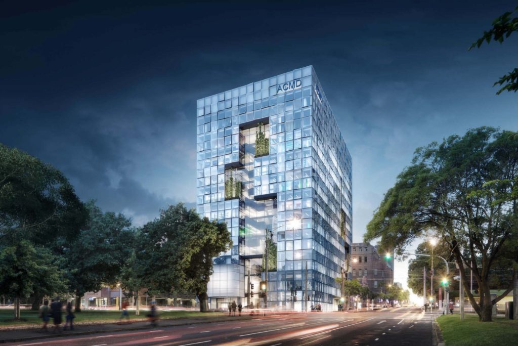
St Vincent’s Hospital recently lodged plans to demolish the building the corner of Victoria Parade and Nicholson Street, a building that overlooks Carlton Gardens. The hospital plans to replace it with a new 11-storey tower with glass façade with parts of the original façade at Daly Wing and Brenan Hall retained. The proposal already raising concerns that it would impact the World Heritage value of the Royal Exhibition Building moments after lodging the plans to City of Yarra Council. According to a statement released by St Vincent’s, the $206 million project, funded by state and federal governments, private philanthropy and project partners, would house a research and training hub, a ground-floor cafe and boast additional rooftop and basement floors. The new building is set to be called the Aikenhead Centre for Medical Discovery and aims to work towards “innovative healthcare solutions for complex chronic diseases”
The application was lodged with the City of Yarra on 21 Dec 2020, and is expected to be brought to a council meeting in Jan 2021. The proposed building falls within the World Heritage Environs Area, a heritage buffer zone for the Royal Exhibition Building and its surrounding Carlton Gardens that extends about block beyond the park’s perimeter.

The Royal Exhibition Building (REB) and Carlton Gardens were inscribed on the UNESCO World Heritage List on 1 July 2004. It was the first built heritage site in Australia to be declared World Heritage because they are the only remaining example of a Palace of Industry from a nineteenth-century world fair on its original site. The site is even more significant because it’s still being used for exhibitions. The heritage buffer zone was introduced by the state government under the requirement of UNESCO to prevent overdevelopment and protect views of the site.

The proposal is already facing opposition from the heritage community. Friends of the Royal Exhibition Building commented the new building design “seems intent on dominating and distracting”. The World Heritage status of the Royal Exhibition Building is up for review this year and The Royal Historical Society of Victoria is “strenuously opposed” to the redevelopment over fears it could impact the review.
A heritage impact statement released by St Vincent’s Hospital said the view of the dome of the Royal Exhibition Building from Victoria Parade would not be impacted by the development, because the view is already blocked by the Aikenhead wing. The new development would be 14.85 metres taller than the current building, but would not cast extra shadow on Carlton Gardens, according to a town planning report lodged by St Vincent’s. The proposal is currently being assessed by the City of Yarra assisted by The National Trust as a referral party. Click Here for the full article from The Age
The proposed redevelopment of Aikenhead wing is not the only controversial the hospital proposed. A separate development at the hospital is yet to begin after it was approved with strict heritage conditions following an appeal in the Victorian Civil and Administrative Tribunal in 2018. St Vincent’s Private Hospital has another 11-storey expansion approved further down Victoria Parade.

The proposal was criticised unusually strong by the Royal Historical Society of Victoria commenting it is “cavalier” and likely to “destroy” the precinct’s low-rise heritage.
“The RHSV is deeply concerned at the impact St Vincent’s proposal would have on the precinct and alarmed at the hospital’s cavalier attitude to the significant heritage value of the area in which it is located,” heritage committee chair, Emeritus Professor Charles Sowerwine, said back in 2018.
Click Here for the full article about the development in Fitzroy.
To boost the recovery of Victoria’s economy after a year of recession brought by the coronavirus (COVID-19), the Victorian Government has identified Victoria’s building and construction sector as a key mechanism to revitalise Victoria’s economy. Back in April 2020, the Victorian Government launched a pilot program, Building Victoria’s Recovery Taskforce Priority Project Fast-Track pilot program. The purpose of the programme was to fast track projects through the town planning process so they could commence on site. The recovery taskforce was setup to identifying projects across the state that are:
- shovel-ready building and construction projects of Victorian State and Regional significance and,
- planning and investment opportunities.
- projects that will provide immediate benefits to Victoria’s economy
- keeping Victorians in work and priority social and economic infrastructure on track for completion.
If the taskforce determined that the project met the criteria then the minister for planning would exercise his power under the Planning and Environment Act 1987 to ‘call the application in’ and his office would essentially replace council as the deciding authority on the application. The Taskforce received 295 applications for assessment of projects to be considered for fast-tracking. The service has proven popular with developers, project proponents and local governments. Applications submitted from across Victoria represent a diversity of projects, including:
- commercial and mixed-use
- hotels
- residential dwellings
- apartments
- social and affordable housing and build – to – rent
- retirement living and aged care
- retail and industrial land.
Following the success of the pilot program, the Minister for Planning, Richard Wynne, has established a twelve-month Development Facilitation Program within the Department of Environment, Land, Water and Planning to speed up the assessment and determination of identified priority projects that:
- Deliver investment into the Victorian economy,
- Keep people in jobs, and
- Provide a substantial public benefit.
Progress to date
Since the introduction of the pilot program and the Development Facilitation Program (DFP), the Planning Minister, has already fast-tracked and approved $7.5 billion worth of projects since March 2020, including one of the largest solar farms in Australia located in regional Wangaratta and a Collingwood commercial development, for the course of generating jobs and help stimulate Victoria’s economic recovery despite both projects been opposed by locals and the local councils.
The commercial development in Collingwood is a 58-metre-tall commercial building in Wellington Street and was opposed by the City of Yarra because of its “excessive” height and scale. At a March planning meeting, the Yarra councillors decided to oppose the 5-green star development because it was not in keeping with the area’s heritage, had “unacceptable” waste management processes, and its failure to achieve “acceptable levels of environmental sustainable design”.
The development than applied for the pilot program and was approved by the Minister who describes the development as having an “acceptable urban design outcome that responds to the emerging character of the area”. The spokeswoman for the Minister’s office further stated 500-600 construction jobs would be needed to build the 15-storey building, which will generate capital expenditure of $214 million and will include landscaping and a new urban plaza on Wellington Street.

As part of the program, the Minister also approved a 13-storey office building with ground-floor retail, near Burnley rail station. The Minister’s office said, this development will generate capital expenditure of $323 million and support 530 construction jobs.

Another project to be fast tracked is a 72-megawatt solar farm on Wangaratta-Kilfeera Road in Laceby, outside Wangaratta. The development was originally designed as a 60-megawatt solar farm with a $93 million price tag, and was opposed by locals who raised concerns about the loss of agricultural land, the risks of fire, and the visual impacts of the solar farm. The Wangaratta Council voted to refuse the planning permit in February but ultimately it was approved by the Minister for Planning eight months later through the Development Facilitation Program.
The solar farm will generate enough power for about 27,000 Victorian households, and is forecast to reduce greenhouse gas emissions by 120,000 tonnes a year which meets all the criteria of the program.
The Development Facilitation Program also helped boost the development of social housing across the state, including a social housing apartment complex in Reservior, consisting 53 two bedroom and three bedroom apartments. The apartment complex is close to public transport and shops, with an $18 million capital expenditure price tag.
As part of the requirements of the Development Facilitation Program, these fast tracked projects are required to commence within 6 – 12 months of approval.
Although the program fast-tracked a number of major projects across the state, almost half the applications were unsuccessful. They did not meet the criteria for a fast track as they were not considered to:
- raise issues of fairness or the public interest, issues of urgency and the public interest would result in immediate action.
- be of State or Regional significance.
- raise a major issue of policy and determination may have a large effect on the achievement or development of planning objectives.
- deliver public value (e.g. public or social housing or environmental sustainability.)
- have been unreasonably delayed.
- provide economic benefits including jobs, capital value, innovation
- Prove project feasibility. Including proof of funding, demand is evident, supply factors mitigated and shovel ready
Project selection
A dedicated facilitation team has been established within DELWP to oversee the program to ensure it is robust and transparent with assistance from Invest Victoria. The team will facilitate projects for accelerated assessment and determination, which includes:
- planning permits; and
- planning scheme amendments.
A project must meet the eligibility criteria below to be recommended for an accelerated assessment and determination. A recommended project does not mean an approved project and the usual planning rules and policies continues to apply.

Project Selection Criteria
Specific criteria have been established by the Department of Environment, Land, Water and Planning to prioritise the assessment and determination of priority projects. The three essential criteria for accelerated assessment and determination include:
Economic:
- The project is of state or regional significance and will have a significant short to medium term economic impact.
Timing:
- The project is “shovel ready” and has investment certainty.
- The technical and compliance matters are resolved or have a clear resolution pathway.
- The views of relevant stakeholders are known.
- The project is dependent on a decision timeframe.
- The project has been unreasonably delayed or impeded.
Policy Alignment and Public benefit:
- The project aligns with government policy and priorities; and
- The project will deliver or is a stimulus to deliver significant public benefit.
The full criteria can be downloaded here.
Given projects that can take part in the program must meet all the criteria of the program, the Development Facilitation Program is heavily weighted to major projects. Even if a project is deemed eligible for the program, it does not necessarily mean a planning permit is guaranteed to be issued by the Minister of Planning.It is recommended that developers continue to do a standard planning application through the local councils and VCAT as the program only assesses if the proposed projects are worthy for the Minister to step in and exercise his power to approve the project.
If you have any questions about the program or have a project that is ready to go and can help the recovery of Victoria’s economy, feel free to get in touch with the team at CS Town Planning Services and we will assist you to take part in the program.
Frequently Ask Questions about the program
How long do I have to make a submission to the Development Facilitation Program?
The program will operate until 31 December 2021.
How long will it take before I know if my project is being referred to the Minister for accelerated assessment and decision?
An initial assessment against the program’s eligibility criteria will typically occur within 14 business days following submission, provided all required information has been provided.
If I apply to the DFP, does this stop a current request before Council or the Victorian Civil and Administrative Tribunal (VCAT)?
No. it is recommended to continue with the usual statutory application process as the Development Facilitation Team are only making recommendations for prioritisation and not decision.
If a project is recommended for prioritisation, is that a guarantee that the Minister will prioritise it?
No. These are recommendations which are non-binding and still provides the Minister with the opportunity to determine the matter as he sees fit.
Am I required to provide financial information for the DFP?
If your project is deemed to have met the eligibility criteria, financial information will be requested to verify project’s feasibility.
If my project is referred and the Minister decides not to intervene, what happens next?
You will be notified in writing of the decision and your project will be required to continue down the normal statutory application process.
If my project is referred and the Minister decides not to intervene, can I challenge this decision?
No, as the DFP is not a formal statutory process. The program has been offered in good faith to assist industry recover from the coronavirus (COVID-19) pandemic.
Do I need to submit a full planning application with technical reports and supporting information?
Yes. The application should include all information that is/would be included in a planning permit application or planning scheme amendment request. Unless all required documentation is submitted, the application will not be assessed.
It is exceptionally rare for a breach in town planning legislation to result in a prison sentence. However, that is exactly the circumstance facing two landowners of a Melbourne City site. Fearing they would not receive the necessary approvals to demolish the heritage building on the site, these unscrupulous owners decided to demolish the building anyway and thought they would be allowed to redevelop the land. However, they greatly underestimated the public backlash and the appetite of the Victorian Government to hold them accountable for the deplorable act. Heritage protection controls are some of the most stringent planning controls that can affect a site and limit the development potential. Any buildings and works to a heritage property can significantly impact and sometimes destroy the heritage fabric of a place so any proposed alterations are carefully scrutinised by heritage experts prior to any building work being completed. The importance of heritage conservation to locally elected councillors and the community was emphasised in a highly publicised case during 2016 within Melbourne city council where the owners of a historic pub that was included in the Victorian Heritage Register was demolished without the necessary approvals.
The building in question was located in Carlton and known as the ‘Corkman Pub’. The building was built in 1858 and in the space of a weekend in October 2016 was fully demolished by the owners. The owners were taken to court for the illegal act in 2019 where a magistrate described the act as ‘reprehensible’ before issuing large fines to the owners which you can read about at this link. The owners originally committed to rebuilding the pub but reneged on this commitment and agreed to clear the site and provide a park instead.

In December 2020 the owners appeared in the news again because they were sentenced to 30 days in jail for contempt of court. In an article published in the Age newspaper two of the owners were described as being jailed as a result of their failure to honour a commitment made during legal proceedings to construct a park on the site. The Supreme Court judge in the matter said the owners had ‘thumbed their noses’ on the previous court order that they act quickly to clean the site and construct the park. Planning Minister Richard Wynne welcomed the decision and said it was appropriate. He added that the government could compulsorily acquire the site but this scenario seems unlikely given the high price tag the site would demand. The sentiments of Minister Wynne were echoed by Melbourne lord Mayor Sally Capp and the liberal opposition planning spokesman Tim Smith. Mayor Capp added that this ruling sends a message to developers that council won’t tolerate developers disobeying court orders or formal agreements.
It is commonplace for land owners to consider ‘heritage overlays’ and ‘heritage listings’ as significant barriers to the development potential of sites. While there is credence to this belief, it is not true to say that just because a property has some form of heritage control that the site is undevelopable and demolition is not possible. Below we look at the town planning heritage controls that can affect a site and describe the likely implications of each for the development potential of the site.
1. A site included in the Victorian Heritage Register.
These sites undoubtly enjoy the greatest level of heritage conservation of any controls that exist. The inclusion of a building or site on the heritage register signifies it is of state significance and is usually accompanied by a ‘Statement of Significance’ that you can read to understand why the property merits inclusion in the state register. The ‘Corkman’ Pub mentioned above was a building that was included in the register and therefore highly protected. It is unlikely its demolition would have been supported and this provides some insight into why the owners rushed the demolition in the space of one weekend and did not seek approvals in advance.
Any demolition, extension or buildings and works to a property included in the register are subject to approval by the department of environment, land, water and planning (DELWP). In some circumstances, where buildings and works are minor the department can issue you an exemption letter like the below one pictured. This exemption is issued when DELWP are comfortable that the proposed works will not impact the heritage fabric of the property and you can continue with the proposal. If the department do not issue an exemption like the below then you will need to apply for a formal permit to undertake the works on the site. This can take months to be approved and is processed similar to a planning permit application.

An important note about properties on the state register is that they are not subject to approval by the local council through a planning permit. Unless there is a subdivision element to the proposal, the local council are not involved in the approval of any buildings and works. This means that once you have your approved exemption from DELWP or an approved permit if required then you do not need to apply to the local council for a planning permit.
2. A site specific heritage overlay
An individual site that is subject to a ‘standalone’ heritage overlay and not included in the state register mentioned previously has been identified by the local council as being of significant heritage value. These sites or buildings have features and characteristics that the local council have deemed necessary for conservation or protection but are not necessarily significant enough to be included on the state register. Similar to properties on the state heritage register these properties will often be accompanied by a ‘statement of significance’ that explains why the property has been included within an overlay and what features of the property are important to retain. Outright demolition of a property that has a site specific heritage overlay is unlikely to be permitted by the local council. Modifications and extensions to properties are supportable on the basis they meet the requirements of the statement of significance. The statement of significance for these properties is usually contained within the ‘Incorporated documents’ section of the planning scheme but can also often be found as a local planning policy clause in some planning schemes.
3. A precinct heritage overlay
This is the most common type of heritage control affecting properties. The difference between a ‘precinct’ overlay and a ‘site specific’ overlay mentioned previously is that a precinct overlay will cover multiple properties and streets and contain a ‘statement of significance’ that describes, in broader terms the common elements of these properties that are worthy of heritage conservation. Typically a ‘statement of significance’ for a precinct overlay will include a list of properties that are either ‘contributory’ or ‘non-contributory’ to the heritage conservation. The classification of a property as ‘contributory’ or ‘non-contributory’ is a very contentious issue and something local councils have to deeply research before deciding. Typically Council will outsource this task to a reputable and impartial heritage consultancy firm. That firm will then define the elements of heritage conservation that are commonplace within a precinct and make a recommendation about whether each individual property that makes up the precinct should be classed as ‘contributory’ or ‘non-contributory’.
Some landowners welcome the security that is perceived by their property being defined as ‘contributory’ under a heritage overlay. They know the features of their property are unlikely to be greatly modified. The majority of landowners would prefer their property be classed as ‘non-contributory’ because of the perceived negative impact on future development potential and land value decline that can result from a ‘contributory’ classification. It is fair to say that councils consent for demolition of a ‘non-contributory’ building is more likely to be approved than a proposal to demolish a ‘contributory building’. However a ‘contributory’ classification does not prohibit or prevent a future extension on your property. It does impede the possibility of an outright demolition of the building being supported in the future. In my experience the only circumstances that the local council will support the demolition of a ‘contributory’ heritage building is when the building is in severe disrepair and the costs of restoration of the building are prohibitively expensive on the landowner.
Heritage controls are a complex but necessary town planning control that exists. The tale of the ‘Corkman’ pub should serve to warn any landowner seeking to circumvent those controls that the legal ramifications can be grave. On the flip side, landowners can often overestimate the limiting impact inclusion within a precinct heritage overlay can have on the development potential of their site. If you have a property within a heritage overlay it is important to find out which of the three types of heritage controls described here affect your property. Our helpful team can answer this question for you quickly and confirm for you the exact implications of the heritage controls affecting your property for the future development potential and value of your site.
The Labour government has promised to deliver a historic $5.3 billion Big Housing Build plan to construct more than 12,000 new homes throughout metro and regional Victoria as part of the 2020/2021 state budget. On December 1st 2020 the planning minister Richard Wynne introduced a sweeping change to planning schemes in the entire state to fast track planning approvals for the housing to be delivered. The package announced in the budget promises to boost the state’s social housing supply by 10 per cent in four years, including replacing 1,100 old public housing units. The program will deliver secure, modern, and affordable homes throughout Victoria – with 25 per cent of funding to be allocated to regional Victoria. The new homes will meet 7-star energy efficiency standards, making them more comfortable during summer and winter, and saving tenants on their power bills.
To ensure the timely delivery of housing, amendment VC187 has been approved on the 1stDecember 2020, to introduce a new particular provision at clause 53.20 to all planning schemes throughout Victoria to streamline the planning permit process for housing projects by or on behalf of the Director of Housing. The amendment considers the net community benefit and aims to ensure that planning applications assessed under the new provisions will pose no negative amenity impacts on neighbours. The new clause applies to applications on residentially zoned land only.
The new particular provision does not exempt development from the requirements of other planning controls such as overlays. These will continue to apply and a proposal must comply with the requirements of any overlay and the new clause 53.20 to receive a permit. The amendment ensures a permit application for a project on behalf of the Director of Housing considers matters such as neighbourhood character, amenity impacts, vehicle access, heritage, built form and environmental values.
The new particular provision specifically exempts planning applications made by or on behalf of the Director of Housing from the following provisions:
- The Municipal Planning Strategy or Municipal Strategic Statement and the Planning Policy Framework.
- An application requirement or decision guideline of a zone.
- A requirement to meet clauses 54, 55 and 58 of a zone.
- A schedule to a zone except for a specified building height requirement.
- Clauses 52.06 and 65.
The clause also exempts these applications from the notice requirements of section 52(1) (a), (b) and (d), the decision requirements of section 64(1), (2) and (3) and the review rights of section 82(2) of the Act. This means the planning applications will not be subject to public advertising and neighbouring properties will not be able to object to the applications made by the Director of Housing in their neighbourhood. The particular provision also removes any appeal rights of neighbours to appeal decisions by council to VCAT.
While the clause exempts the applications made by the Director of Housing from multiple traditional clauses and guidelines such as ResCode, the clause 53.20 itself consist of multiple application requirements and development standards which apply to all applications made by the Director of Housing across all municipalities. The most notable development standards are noted below:
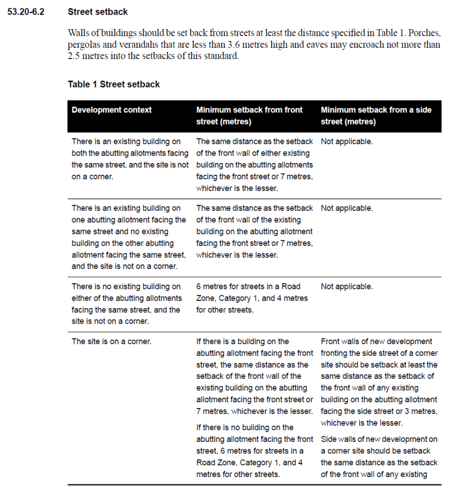
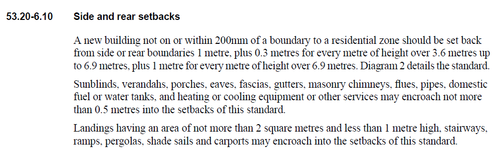
Other than the above, the clause includes other standards that are similar to the ResCode, such as Private Open Space, Access, Walls on Boundaries, Overlooking and Overshadowing requirements.
The clause also includes requirements for the design of new driveways and vehicular access and car parking arrangements. These requirements are consistent with Clause 52.06 of the planning scheme are largely a transfer of pre-existing requirements and no new measures are introduced.

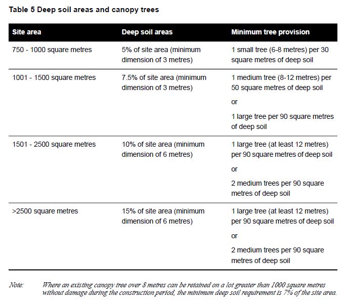
The particular provision also applies standards for new apartment design in relation to energy rating requirements and also dedicated deep soil areas for canopy tree planting in relation to numbers of trees to be planted on site as part of apartment developments. The requirements are set out in the table below:
The full clause can now be found in all planning schemes of Victoria. Throughout 2020 the planning team at CS have been working with Simmonds Homes in obtaining planning permits for these projects throughout the state on behalf of the Director of Housing. We welcome the introduction on the new clause and believe it will fast track the delivery of these projects throughout the state and we congratulate the Victorian Department of Health and Human Services on the approval of this amendment and wish them every success in providing the housing. There has been a negative reaction to the change by a number of the Victorian Councils who fear that it paves the way for social housing projects with no consultation with existing residents. The liberal members of parliament and CEO’s from Boroondara and Stonnington have expressed concerns and criticised the Labour government for the change in a recent article published in the Age newspaper. The mayor of Bayside Council has expressed concerns that the proposal will allow for high rise public housing towers in suburbs like Bayside but added that he supports the development of low rise public housing that combines both public and private ownership.
When talking about permit applications, many understand the difference between a planning permit and a building permit. Building permits relate to the method of construction of a building or development where planning permits is a legal document that allows a certain use and / or development on land. Most people are aware they need a planning permit to build or develop but few are aware of the need to get a planning permit to use a building for a specific use if is required within the zone, even if they don’t plan to build or develop. In this article, we will explain what is required in order to obtain a planning permit to use a building for a specific use if it is required within the zone.
In each of the planning zones, all uses are broken down into 3 sections:
Section 1 use – Permit not required
Section 2 use – Permit Required
Section 3 use – Prohibited
Each section lists out all the uses that fall under that specific section with the conditions applied to each specific use. It is important to check these table of uses for each property because a use can be a section 1 use in one particular zone and a section 3 use in another zone; but also each council can have different conditions applied to the same use.
Using a ‘Dwelling’ as an example, it is a Section 1 use under the General Residential Zone within City of Stonnington Planning Scheme but it is a Section 2 use under Industrial Zone 3 within the same planning scheme. This means the use of a building in the general residential zone for a dwelling is a ‘as of right’ use and you do not need council approval to use a building as a dwelling. However in the industrial 3 zone the use of a building for a dwelling requires council approval.
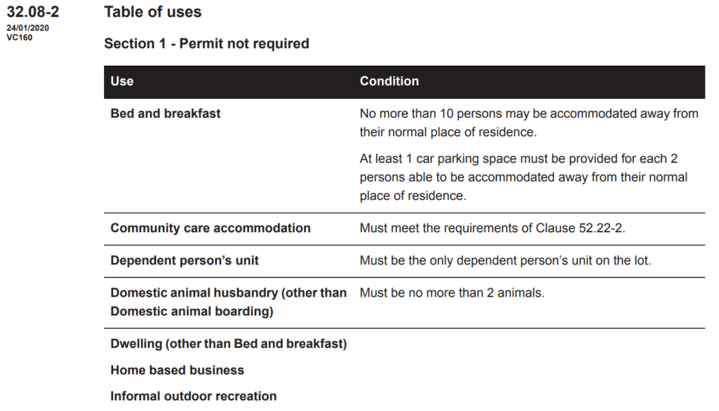
The use of a building as a dwelling is not prohibited in Industrial Zone 3 because it is listed as “Any other use not in Section 1 or 3” so a permit is required.

The categories are set this way because councils don’t want industrial land use to be incrementally eroded or creating a situation that will lead to conflicts between owners while keeping the options open and providing them with the flexibility to allow other uses in the future. If the council do decide to approve a permit for the use of a dwelling within an industrial zone, it is likely conditions such as sound proofing measures and soil test requirements are included in the permit.
When applying for a Change of Use planning permit for medical centres, gymnasiums, childcare centres and other commercial use or industrial use, a number of documents and information are required, a list of commonly required information is:
- Description of the business
- Hours of operation
- Number of staff
- Car parking assessment
- Acoustics report
With the help of a professional town planner, most Change of Use permit applications will be approved if it is identified as a Section 2 use within the zone and almost all permits will have conditions attached.
Example 1 – A gymnasium is proposed next to General Residential Zone land.
A gym is likely to be classified as a Section 2 use in most zones with car parking conditions applied. In this example, the gym is also located closely to residential zone. When council is assessing the application, supply of on-site parking and noise level will be the main factors to be considered. With an appropriately prepared traffic management plan and acoustic report, the application is likely to be approved by council with conditions such as an operating time between 6am – 9pm and not more than a certain number of customers at any one time.
Example 2 – A restaurant (other than take away food premises) is proposed within an industrial zone
A restaurant is likely to be classified as a Section 2 use within an industrial zone, unlike a take away food premises, it is expected to customers will be on-site for a long period of time. If the car parking supply on-site is low and is not proposed to be increased as part of the application, the proposed Change of Use permit maybe approved by the council but due to the low car parking supply there may be stringent conditions such as the number of staff or customers permitted on site at any one time being capped.
A common pitfall of many business owners is to sign a lease on a building and not realise their business is a section 2 use and they need a council issued planning permit to use that building for their business. Even if their fitout of the building is exempt from a planning permit it is very likely they will need a planning permit for the use.
Change of Use permits are often combined with Buildings and Works permits. This means you apply to council for a dual approval as part of one planning application. When your permit is issued the title of what the permit allows will include use and buildings and works. If you require assistance with permit applications, please feel free to contact our team and see how we can help you obtain a permit for your business smoothly.